Lauchheim geodata
Lauchheim (Baden-Württemberg) is a populated place; located in Germany in Europe/Berlin (GMT+2) time zone. With population of 4,609 people, there are 2982 cities with bigger population in this country. Compared to other cities in Germany, 84.5% of cities are located further ↑North; 54.2% of cities are located further ←West and 87.7% of cities have lower elevation than Lauchheim. Note1
Administrative division(s):
- Level 1: Baden-Württemberg
- Level 2: Regierungsbezirk Stuttgart
- Level 3: Ostalbkreis
- Level 4: Lauchheim


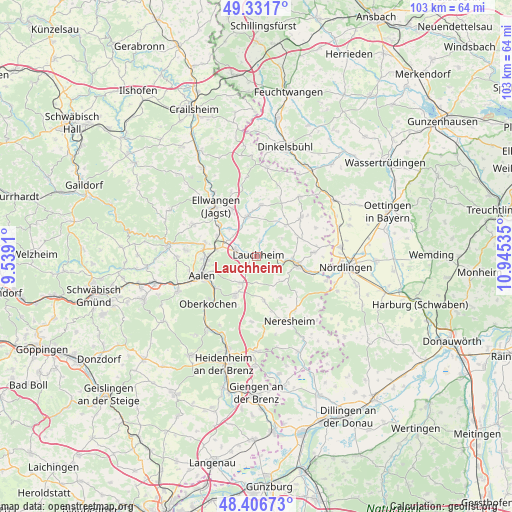
Lauchheim GPS coordinates[2]
48° 52' 16.86" North, 10° 14' 31.992" East
| Map corner | latitude | longitude |
|---|---|---|
| Upper-left | 49.3317°, | 9.5391° |
| Center: | 48.87135°, | 10.24222° |
| Lower-right: | 48.40673°, | 10.94535° |
| Map W x H: | 102.8×102.8 km | = 63.9×63.9mi |
| max Lat: | 55.01917° ⇑84.5% North |
| Lauchheim: | 48.87135° |
| min Lat: | ⇓15.5% South 47.40724° |
| min Long | Lauchheim | max Long |
| 5.92978° | 10.24222° | 14.98853° |
| W 54.2%⇐ | ⇒45.8% E |
Elevation
Elevation of Lauchheim is 491 m = 1611 ft, and this is 241.9 m = 794 ft above average elevation for this country.
| Max E: |
1256 m = 4121 ft | 12.3% |
| Lauchheim | 491 m 1611 ft | |
| Avg. | 249.1 m = 817 ft | |
Min E: |
-5 m = -16 ft | 87.7% |
See also: Germany elevation on elevation.city.
Geographical zone
Lauchheim is located in North temperate zone (between Tropic of Cancer and the Arctic Circle). Distance of this North polar circle is 1967.2 km =1222.4 mi to North.| Distance of | km | miles | from Lauchheim |
|---|---|---|---|
| North Pole | 4573.1 | 2841.6 | to North |
| Arctic Circle | 1967.2 | 1222.4 | to North |
| Tropic Cancer | 2828.1 | 1757.3 | to South |
| Equator | 5434 | 3376.5 | to South |


Nearby cities:
15 places around Lauchheim: (largest is in red/bold)
• Aalen
11.5 km =7.1 mi,  251°
251°
• Bopfingen
8.3 km =5.2 mi,  99°
99°
• Ellenberg
16.3 km =10.1 mi,  353°
353°
• Ellwangen
12.9 km =8 mi,  321°
321°
• Hüttlingen
10.6 km =6.6 mi,  282°
282°
• Kirchheim am Ries
11.6 km =7.2 mi,  85°
85°
• Königsbronn
17.2 km =10.7 mi,  213°
213°
• Neresheim
14.4 km =8.9 mi,  153°
153°
• Neuler
14.2 km =8.8 mi,  296°
296°
• Oberkochen
14 km =8.7 mi,  225°
225°
• Stödtlen
14.9 km =9.3 mi,  16°
16°
• Tannhausen
14.8 km =9.2 mi,  36°
36°
• Unterschneidheim
11.4 km =7.1 mi,  52°
52°
• Wallerstein
17.2 km =10.7 mi,  84°
84°
• Westhausen
4.5 km =2.8 mi,  287°
287°
Sources, notices
• [Note1] Compared only with cities in Germany existing in our database
• [Src1] Map data: © OpenStreetMap contributors (CC-BY-SA)
• [Src2] Other city data from geonames.org with taken over terms of usage.
• [Src3] Geographical zone / Annual Mean Temperature by Robert A. Rohde @ Wikipedia
