Hagen im Bremischen geodata
Hagen im Bremischen (Lower Saxony) is a seat of a fourth-order administrative division; located in Germany in Europe/Berlin (GMT+2) time zone. With population of 3,928 people, there are 3332 cities with bigger population in this country. Compared to other cities in Germany, 84.2% of cities are located further ↓South; 69.7% of cities are located further →East and 93.5% of cities have higher elevation than Hagen im Bremischen. Note1
Administrative division(s):
- Level 1: Lower Saxony
- Level 3: Landkreis Cuxhaven
- Level 4: Hagen im Bremischen


Hagen im Bremischen GPS coordinates[2]
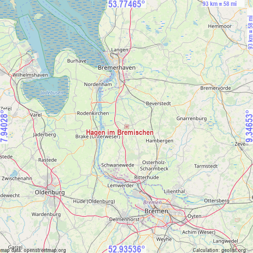
53° 21' 25.452" North, 8° 38' 36.276" East
| Map corner | latitude | longitude |
|---|---|---|
| Upper-left | 53.77465°, | 7.94028° |
| Center: | 53.35707°, | 8.64341° |
| Lower-right: | 52.93536°, | 9.34653° |
| Map W x H: | 93.3×93.3 km | = 58×58mi |
| max Lat: | 55.01917° ⇑15.8% North |
| Hagen im Bremischen: | 53.35707° |
| min Lat: | ⇓84.2% South 47.40724° |
| min Long | Hagen im Bremis | max Long |
| 5.92978° | 8.64341° | 14.98853° |
| W 30.3%⇐ | ⇒69.7% E |
Elevation
Elevation of Hagen im Bremischen is 12 m = 39 ft, and this is 237.1 m = 778 ft below average elevation for this country.
| Max E: |
1256 m = 4121 ft | 93.5% |
| Avg. | 249.1 m = 817 ft | |
| Hagen im Bremischen | 12 m = 39 ft | |
Min E: |
-5 m = -16 ft | 6.5% |
See also: Germany elevation on elevation.city.
Geographical zone
Hagen im Bremischen is located in North temperate zone (between Tropic of Cancer and the Arctic Circle). Distance of this North polar circle is 1468.4 km =912.4 mi to North.| Distance of | km | miles | from Hagen im Bremischen |
|---|---|---|---|
| North Pole | 4074.3 | 2531.7 | to North |
| Arctic Circle | 1468.4 | 912.4 | to North |
| Tropic Cancer | 3326.8 | 2067.2 | to South |
| Equator | 5932.8 | 3686.5 | to South |


Nearby cities:
15 places around Hagen im Bremischen: (largest is in red/bold)
• Axstedt
8.7 km =5.4 mi,  91°
91°
• Bokel
9.2 km =5.7 mi,  64°
64°
• Brake (Unterweser)
10.9 km =6.8 mi,  256°
256°
• Bramstedt
3.3 km =2.1 mi,  72°
72°
• Driftsethe
3.4 km =2.1 mi,  328°
328°
• Hambergen
13.2 km =8.2 mi,  114°
114°
• Hollen
8.6 km =5.3 mi,  28°
28°
• Loxstedt
12.2 km =7.6 mi,  2°
2°
• Lunestedt
11.4 km =7.1 mi,  39°
39°
• Lübberstedt
10.7 km =6.6 mi,  104°
104°
• Sandstedt
8.1 km =5 mi,  272°
272°
• Schwanewede
14.1 km =8.8 mi,  191°
191°
• Stinstedt
13.6 km =8.5 mi,  18°
18°
• Uthlede
6.7 km =4.2 mi,  220°
220°
• Wulsbüttel
4.8 km =3 mi,  161°
161°
Sources, notices
• [Note1] Compared only with cities in Germany existing in our database
• [Src1] Map data: © OpenStreetMap contributors (CC-BY-SA)
• [Src2] Other city data from geonames.org with taken over terms of usage.
• [Src3] Geographical zone / Annual Mean Temperature by Robert A. Rohde @ Wikipedia
