Bodenmais geodata
Bodenmais (Bavaria) is a populated place; located in Germany in Europe/Berlin (GMT+2) time zone. With population of 3,362 people, there are 3712 cities with bigger population in this country. Compared to other cities in Germany, 82.2% of cities are located further ↑North; 93% of cities are located further ←West and 97.6% of cities have lower elevation than Bodenmais. Note1
Administrative division(s):
- Level 1: Bavaria
- Level 2: Lower Bavaria
- Level 3: Landkreis Regen
- Level 4: Bodenmais, Markt


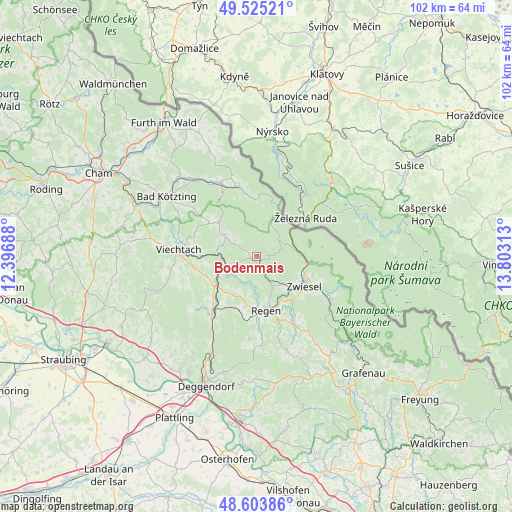
Bodenmais GPS coordinates[2]
49° 4' 0.012" North, 13° 6' 0" East
| Map corner | latitude | longitude |
|---|---|---|
| Upper-left | 49.52521°, | 12.39688° |
| Center: | 49.06667°, | 13.1° |
| Lower-right: | 48.60386°, | 13.80313° |
| Map W x H: | 102.4×102.4 km | = 63.6×63.6mi |
| max Lat: | 55.01917° ⇑82.2% North |
| Bodenmais: | 49.06667° |
| min Lat: | ⇓17.8% South 47.40724° |
| min Long | Bodenmais | max Long |
| 5.92978° | 13.1° | 14.98853° |
| W 93%⇐ | ⇒7% E |
Elevation
Elevation of Bodenmais is 690 m = 2264 ft, and this is 440.9 m = 1447 ft above average elevation for this country.
| Max E: |
1256 m = 4121 ft | 2.4% |
| Bodenmais | 690 m 2264 ft | |
| Avg. | 249.1 m = 817 ft | |
Min E: |
-5 m = -16 ft | 97.6% |
See also: Germany elevation on elevation.city.
Geographical zone
Bodenmais is located in North temperate zone (between Tropic of Cancer and the Arctic Circle). Distance of this North polar circle is 1945.5 km =1208.9 mi to North.| Distance of | km | miles | from Bodenmais |
|---|---|---|---|
| North Pole | 4551.4 | 2828.1 | to North |
| Arctic Circle | 1945.5 | 1208.9 | to North |
| Tropic Cancer | 2849.8 | 1770.8 | to South |
| Equator | 5455.7 | 3390 | to South |


Nearby cities:
15 places around Bodenmais: (largest is in red/bold)
• Arnbruck
10.2 km =6.3 mi,  313°
313°
• Bayerisch Eisenstein
9.2 km =5.7 mi,  52°
52°
• Böbrach
4.9 km =3 mi,  256°
256°
• Drachselsried
7.9 km =4.9 mi, 305°
• Geiersthal
8.9 km =5.5 mi,  254°
254°
• Gotteszell
14.8 km =9.2 mi,  221°
221°
• Langdorf
6.7 km =4.2 mi,  149°
149°
• Lindberg
11.7 km =7.3 mi,  106°
106°
• Lohberg
12.2 km =7.6 mi,  1°
1°
• Patersdorf
10.2 km =6.3 mi,  236°
236°
• Regen
10.7 km =6.6 mi,  168°
168°
• Ruhmannsfelden
12.6 km =7.8 mi, 222°
• Teisnach
8.7 km =5.4 mi, 250°
• Zachenberg
13.3 km =8.3 mi,  213°
213°
• Zwiesel
11.5 km =7.1 mi,  118°
118°
Sources, notices
• [Note1] Compared only with cities in Germany existing in our database
• [Src1] Map data: © OpenStreetMap contributors (CC-BY-SA)
• [Src2] Other city data from geonames.org with taken over terms of usage.
• [Src3] Geographical zone / Annual Mean Temperature by Robert A. Rohde @ Wikipedia
