Zwiesel geodata
Zwiesel (Bavaria) is a populated place; located in Germany in Europe/Berlin (GMT+2) time zone. With population of 10,327 people, there are 1589 cities with bigger population in this country. Compared to other cities in Germany, 82.8% of cities are located further ↑North; 93.9% of cities are located further ←West and 96% of cities have lower elevation than Zwiesel. Note1
Administrative division(s):
- Level 1: Bavaria
- Level 2: Lower Bavaria
- Level 3: Landkreis Regen
- Level 4: Zwiesel


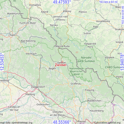
Zwiesel GPS coordinates[2]
49° 1' 0.948" North, 13° 14' 15.54" East
| Map corner | latitude | longitude |
|---|---|---|
| Upper-left | 49.47593°, | 12.53453° |
| Center: | 49.01693°, | 13.23765° |
| Lower-right: | 48.55366°, | 13.94078° |
| Map W x H: | 102.5×102.5 km | = 63.7×63.7mi |
| max Lat: | 55.01917° ⇑82.8% North |
| Zwiesel: | 49.01693° |
| min Lat: | ⇓17.2% South 47.40724° |
| min Long | Zwiesel | max Long |
| 5.92978° | 13.23765° | 14.98853° |
| W 93.9%⇐ | ⇒6.1% E |
Elevation
Elevation of Zwiesel is 629 m = 2064 ft, and this is 379.9 m = 1246 ft above average elevation for this country.
| Max E: |
1256 m = 4121 ft | 4% |
| Zwiesel | 629 m 2064 ft | |
| Avg. | 249.1 m = 817 ft | |
Min E: |
-5 m = -16 ft | 96% |
See also: Germany elevation on elevation.city.
Geographical zone
Zwiesel is located in North temperate zone (between Tropic of Cancer and the Arctic Circle). Distance of this North polar circle is 1951 km =1212.3 mi to North.| Distance of | km | miles | from Zwiesel |
|---|---|---|---|
| North Pole | 4556.9 | 2831.5 | to North |
| Arctic Circle | 1951 | 1212.3 | to North |
| Tropic Cancer | 2844.3 | 1767.4 | to South |
| Equator | 5450.2 | 3386.6 | to South |


Nearby cities:
15 places around Zwiesel: (largest is in red/bold)
• Bayerisch Eisenstein
11.4 km =7.1 mi,  346°
346°
• Bischofsmais
15.8 km =9.8 mi,  225°
225°
• Bodenmais
11.5 km =7.1 mi,  298°
298°
• Böbrach
15.4 km =9.6 mi,  286°
286°
• Eppenschlag
14.9 km =9.3 mi,  162°
162°
• Frauenau
5.6 km =3.5 mi,  124°
124°
• Kirchberg
13.6 km =8.5 mi,  197°
197°
• Kirchdorf im Wald
12 km =7.5 mi,  170°
170°
• Langdorf
6.6 km =4.1 mi,  268°
268°
• Lindberg
2.5 km =1.6 mi,  28°
28°
• Regen
9.4 km =5.8 mi,  237°
237°
• Rinchnach
8 km =5 mi, 199°
• Spiegelau
14.5 km =9 mi,  141°
141°
• Teisnach
18.4 km =11.4 mi,  278°
278°
• Zachenberg
18.2 km =11.3 mi,  252°
252°
Sources, notices
• [Note1] Compared only with cities in Germany existing in our database
• [Src1] Map data: © OpenStreetMap contributors (CC-BY-SA)
• [Src2] Other city data from geonames.org with taken over terms of usage.
• [Src3] Geographical zone / Annual Mean Temperature by Robert A. Rohde @ Wikipedia
