Langdorf geodata
Langdorf (Bavaria) is a seat of a fourth-order administrative division; located in Germany in Europe/Berlin (GMT+2) time zone. In our database, there are 11009 cities with bigger population. Compared to other cities in Germany, 82.9% of cities are located further ↑North; 93.3% of cities are located further ←West and 97.1% of cities have lower elevation than Langdorf. Note1
Administrative division(s):
- Level 1: Bavaria
- Level 2: Lower Bavaria
- Level 3: Landkreis Regen
- Level 4: Langdorf


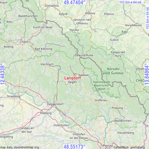
Langdorf GPS coordinates[2]
49° 0' 54.072" North, 13° 8' 47.436" East
| Map corner | latitude | longitude |
|---|---|---|
| Upper-left | 49.47404°, | 12.44339° |
| Center: | 49.01502°, | 13.14651° |
| Lower-right: | 48.55173°, | 13.84964° |
| Map W x H: | 102.6×102.5 km | = 63.8×63.7mi |
| max Lat: | 55.01917° ⇑82.9% North |
| Langdorf: | 49.01502° |
| min Lat: | ⇓17.1% South 47.40724° |
| min Long | Langdorf | max Long |
| 5.92978° | 13.14651° | 14.98853° |
| W 93.3%⇐ | ⇒6.7% E |
Elevation
Elevation of Langdorf is 667 m = 2188 ft, and this is 417.9 m = 1371 ft above average elevation for this country.
| Max E: |
1256 m = 4121 ft | 2.9% |
| Langdorf | 667 m 2188 ft | |
| Avg. | 249.1 m = 817 ft | |
Min E: |
-5 m = -16 ft | 97.1% |
See also: Germany elevation on elevation.city.
Geographical zone
Langdorf is located in North temperate zone (between Tropic of Cancer and the Arctic Circle). Distance of this North polar circle is 1951.2 km =1212.4 mi to North.| Distance of | km | miles | from Langdorf |
|---|---|---|---|
| North Pole | 4557.1 | 2831.6 | to North |
| Arctic Circle | 1951.2 | 1212.4 | to North |
| Tropic Cancer | 2844 | 1767.2 | to South |
| Equator | 5450 | 3386.5 | to South |


Nearby cities:
15 places around Langdorf: (largest is in red/bold)
• Bayerisch Eisenstein
12 km =7.5 mi,  19°
19°
• Bischofsmais
11.8 km =7.3 mi,  203°
203°
• Bodenmais
6.7 km =4.2 mi,  329°
329°
• Böbrach
9.3 km =5.8 mi,  299°
299°
• Frauenau
11.6 km =7.2 mi,  104°
104°
• Geiersthal
12.5 km =7.8 mi,  285°
285°
• Kirchberg
13 km =8.1 mi,  168°
168°
• Lindberg
8.2 km =5.1 mi,  72°
72°
• Patersdorf
11.9 km =7.4 mi,  270°
270°
• Regen
5 km =3.1 mi, 195°
• Rinchnach
8.3 km =5.2 mi,  151°
151°
• Ruhmannsfelden
12.4 km =7.7 mi,  253°
253°
• Teisnach
11.9 km =7.4 mi,  284°
284°
• Zachenberg
12 km =7.5 mi,  243°
243°
• Zwiesel
6.6 km =4.1 mi,  88°
88°
Sources, notices
• [Note1] Compared only with cities in Germany existing in our database
• [Src1] Map data: © OpenStreetMap contributors (CC-BY-SA)
• [Src2] Other city data from geonames.org with taken over terms of usage.
• [Src3] Geographical zone / Annual Mean Temperature by Robert A. Rohde @ Wikipedia
