Lindberg geodata
Lindberg (Bavaria) is a seat of a fourth-order administrative division; located in Germany in Europe/Berlin (GMT+2) time zone. With population of 2,355 people, there are 4598 cities with bigger population in this country. Compared to other cities in Germany, 82.6% of cities are located further ↑North; 94% of cities are located further ←West and 97.2% of cities have lower elevation than Lindberg. Note1
Administrative division(s):
- Level 1: Bavaria
- Level 2: Lower Bavaria
- Level 3: Landkreis Regen
- Level 4: Lindberg


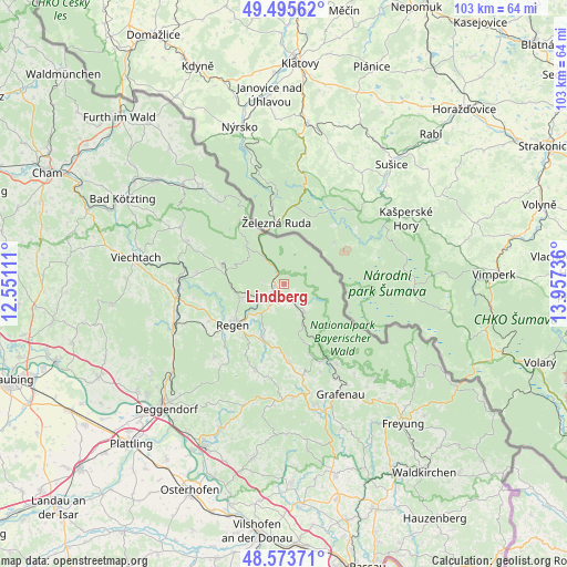
Lindberg GPS coordinates[2]
49° 2' 12.48" North, 13° 15' 15.228" East
| Map corner | latitude | longitude |
|---|---|---|
| Upper-left | 49.49562°, | 12.55111° |
| Center: | 49.0368°, | 13.25423° |
| Lower-right: | 48.57371°, | 13.95736° |
| Map W x H: | 102.5×102.5 km | = 63.7×63.7mi |
| max Lat: | 55.01917° ⇑82.6% North |
| Lindberg: | 49.0368° |
| min Lat: | ⇓17.4% South 47.40724° |
| min Long | Lindberg | max Long |
| 5.92978° | 13.25423° | 14.98853° |
| W 94%⇐ | ⇒6% E |
Elevation
Elevation of Lindberg is 670 m = 2198 ft, and this is 420.9 m = 1381 ft above average elevation for this country.
| Max E: |
1256 m = 4121 ft | 2.8% |
| Lindberg | 670 m 2198 ft | |
| Avg. | 249.1 m = 817 ft | |
Min E: |
-5 m = -16 ft | 97.2% |
See also: Germany elevation on elevation.city.
Geographical zone
Lindberg is located in North temperate zone (between Tropic of Cancer and the Arctic Circle). Distance of this North polar circle is 1948.8 km =1210.9 mi to North.| Distance of | km | miles | from Lindberg |
|---|---|---|---|
| North Pole | 4554.7 | 2830.2 | to North |
| Arctic Circle | 1948.8 | 1210.9 | to North |
| Tropic Cancer | 2846.5 | 1768.7 | to South |
| Equator | 5452.4 | 3388 | to South |


Nearby cities:
15 places around Lindberg: (largest is in red/bold)
• Bayerisch Eisenstein
9.7 km =6 mi,  336°
336°
• Bischofsmais
18.2 km =11.3 mi,  223°
223°
• Bodenmais
11.7 km =7.3 mi,  286°
286°
• Böbrach
16.1 km =10 mi,  277°
277°
• Drachselsried
19.3 km =12 mi, 294°
• Eppenschlag
16.7 km =10.4 mi,  168°
168°
• Frauenau
6.3 km =3.9 mi,  147°
147°
• Kirchberg
16.1 km =10 mi,  199°
199°
• Kirchdorf im Wald
14.1 km =8.8 mi,  176°
176°
• Langdorf
8.2 km =5.1 mi,  252°
252°
• Lohberg
18.9 km =11.7 mi,  325°
325°
• Regen
11.7 km =7.3 mi,  231°
231°
• Rinchnach
10.4 km =6.5 mi, 201°
• Spiegelau
15.7 km =9.8 mi, 149°
• Zwiesel
2.5 km =1.6 mi,  208°
208°
Sources, notices
• [Note1] Compared only with cities in Germany existing in our database
• [Src1] Map data: © OpenStreetMap contributors (CC-BY-SA)
• [Src2] Other city data from geonames.org with taken over terms of usage.
• [Src3] Geographical zone / Annual Mean Temperature by Robert A. Rohde @ Wikipedia
