Bayerisch Eisenstein geodata
Bayerisch Eisenstein (Bavaria) is a seat of a fourth-order administrative division; located in Germany in Europe/Berlin (GMT+2) time zone. With population of 1,318 people, there are 6255 cities with bigger population in this country. Compared to other cities in Germany, 81.5% of cities are located further ↑North; 93.7% of cities are located further ←West and 99.1% of cities have lower elevation than Bayerisch Eisenstein. Note1
Administrative division(s):
- Level 1: Bavaria
- Level 2: Lower Bavaria
- Level 3: Landkreis Regen
- Level 4: Bayerisch Eisenstein


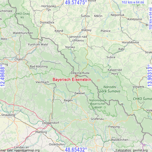
Bayerisch Eisenstein GPS coordinates[2]
49° 7' 0.012" North, 13° 12' 0" East
| Map corner | latitude | longitude |
|---|---|---|
| Upper-left | 49.57475°, | 12.49688° |
| Center: | 49.11667°, | 13.2° |
| Lower-right: | 48.65432°, | 13.90313° |
| Map W x H: | 102.3×102.3 km | = 63.6×63.6mi |
| max Lat: | 55.01917° ⇑81.5% North |
| Bayerisch Eisenstein: | 49.11667° |
| min Lat: | ⇓18.5% South 47.40724° |
| min Long | Bayerisch Eisen | max Long |
| 5.92978° | 13.2° | 14.98853° |
| W 93.7%⇐ | ⇒6.3% E |
Elevation
Elevation of Bayerisch Eisenstein is 789 m = 2589 ft, and this is 539.9 m = 1771 ft above average elevation for this country.
| Max E: |
1256 m = 4121 ft | 0.90000000000001% |
| Bayerisch Eisenstein | 789 m 2589 ft | |
| Avg. | 249.1 m = 817 ft | |
Min E: |
-5 m = -16 ft | 99.1% |
See also: Germany elevation on elevation.city.
Geographical zone
Bayerisch Eisenstein is located in North temperate zone (between Tropic of Cancer and the Arctic Circle). Distance of this North polar circle is 1939.9 km =1205.4 mi to North.| Distance of | km | miles | from Bayerisch Eisenstein |
|---|---|---|---|
| North Pole | 4545.8 | 2824.6 | to North |
| Arctic Circle | 1939.9 | 1205.4 | to North |
| Tropic Cancer | 2855.3 | 1774.2 | to South |
| Equator | 5461.3 | 3393.5 | to South |


Nearby cities:
15 places around Bayerisch Eisenstein: (largest is in red/bold)
• Arnbruck
14.8 km =9.2 mi,  275°
275°
• Arrach
17.1 km =10.6 mi,  299°
299°
• Bodenmais
9.2 km =5.7 mi,  232°
232°
• Böbrach
13.8 km =8.6 mi,  240°
240°
• Drachselsried
13.7 km =8.5 mi,  265°
265°
• Frauenau
16 km =9.9 mi,  152°
152°
• Geiersthal
17.7 km =11 mi, 243°
• Lam
14 km =8.7 mi,  309°
309°
• Langdorf
12 km =7.5 mi,  199°
199°
• Lindberg
9.7 km =6 mi,  156°
156°
• Lohberg
9.5 km =5.9 mi, 313°
• Regen
16.9 km =10.5 mi, 197°
• Rinchnach
18.6 km =11.6 mi,  179°
179°
• Teisnach
17.6 km =10.9 mi, 241°
• Zwiesel
11.4 km =7.1 mi,  166°
166°
Sources, notices
• [Note1] Compared only with cities in Germany existing in our database
• [Src1] Map data: © OpenStreetMap contributors (CC-BY-SA)
• [Src2] Other city data from geonames.org with taken over terms of usage.
• [Src3] Geographical zone / Annual Mean Temperature by Robert A. Rohde @ Wikipedia
