Blankenberg geodata
Blankenberg (Thuringia) is a seat of a fourth-order administrative division; located in Germany in Europe/Berlin (GMT+2) time zone. In our database, there are 11009 cities with bigger population. Compared to other cities in Germany, 54.5% of cities are located further ↑North; 77.4% of cities are located further ←West and 87.9% of cities have lower elevation than Blankenberg. Note1
Administrative division(s):
- Level 1: Thuringia
- Level 3: Saale-Orla-Kreis
- Level 4: Rosenthal am Rennsteig


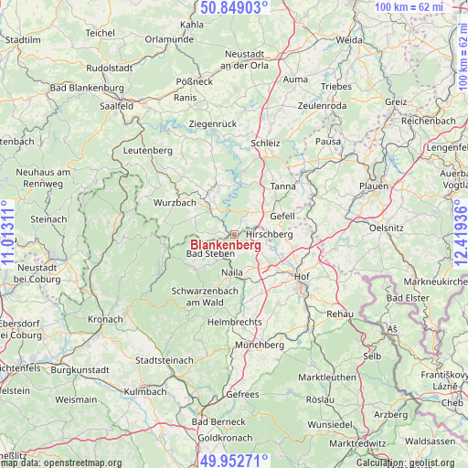
Blankenberg GPS coordinates[2]
50° 24' 10.764" North, 11° 42' 58.428" East
| Map corner | latitude | longitude |
|---|---|---|
| Upper-left | 50.84903°, | 11.01311° |
| Center: | 50.40299°, | 11.71623° |
| Lower-right: | 49.95271°, | 12.41936° |
| Map W x H: | 99.7×99.7 km | = 62×62mi |
| max Lat: | 55.01917° ⇑54.5% North |
| Blankenberg: | 50.40299° |
| min Lat: | ⇓45.5% South 47.40724° |
| min Long | Blankenberg | max Long |
| 5.92978° | 11.71623° | 14.98853° |
| W 77.4%⇐ | ⇒22.6% E |
Elevation
Elevation of Blankenberg is 493 m = 1617 ft, and this is 243.9 m = 800 ft above average elevation for this country.
| Max E: |
1256 m = 4121 ft | 12.1% |
| Blankenberg | 493 m 1617 ft | |
| Avg. | 249.1 m = 817 ft | |
Min E: |
-5 m = -16 ft | 87.9% |
See also: Germany elevation on elevation.city.
Geographical zone
Blankenberg is located in North temperate zone (between Tropic of Cancer and the Arctic Circle). Distance of this North polar circle is 1796.9 km =1116.5 mi to North.| Distance of | km | miles | from Blankenberg |
|---|---|---|---|
| North Pole | 4402.8 | 2735.8 | to North |
| Arctic Circle | 1796.9 | 1116.5 | to North |
| Tropic Cancer | 2998.4 | 1863.1 | to South |
| Equator | 5604.3 | 3482.3 | to South |


Nearby cities:
15 places around Blankenberg: (largest is in red/bold)
• Bad Lobenstein
7.7 km =4.8 mi,  315°
315°
• Bad Steben
6.5 km =4 mi,  231°
231°
• Berg
5.4 km =3.4 mi,  125°
125°
• Birkenhügel
4.1 km =2.5 mi,  35°
35°
• Blankenstein
1.2 km =0.7 mi,  265°
265°
• Geroldsgrün
11.3 km =7 mi, 226°
• Harra
2.8 km =1.7 mi,  303°
303°
• Issigau
3.1 km =1.9 mi,  174°
174°
• Köditz
12.2 km =7.6 mi, 129°
• Lichtenberg
3.6 km =2.2 mi, 232°
• Naila
8.1 km =5 mi,  185°
185°
• Pottiga
2.2 km =1.4 mi,  53°
53°
• Schlegel
7.1 km =4.4 mi, 267°
• Selbitz
9.9 km =6.2 mi, 165°
• Töpen
11.2 km =7 mi,  97°
97°
Sources, notices
• [Note1] Compared only with cities in Germany existing in our database
• [Src1] Map data: © OpenStreetMap contributors (CC-BY-SA)
• [Src2] Other city data from geonames.org with taken over terms of usage.
• [Src3] Geographical zone / Annual Mean Temperature by Robert A. Rohde @ Wikipedia
