Bad Steben geodata
Bad Steben (Bavaria) is a populated place; located in Germany in Europe/Berlin (GMT+2) time zone. With population of 3,640 people, there are 3511 cities with bigger population in this country. Compared to other cities in Germany, 55.4% of cities are located further ↑North; 76.4% of cities are located further ←West and 94.3% of cities have lower elevation than Bad Steben. Note1
Administrative division(s):
- Level 1: Bavaria
- Level 2: Upper Franconia
- Level 3: Landkreis Hof
- Level 4: Bad Steben, Markt


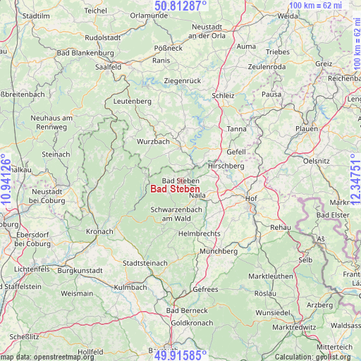
Bad Steben GPS coordinates[2]
50° 21' 59.328" North, 11° 38' 39.768" East
| Map corner | latitude | longitude |
|---|---|---|
| Upper-left | 50.81287°, | 10.94126° |
| Center: | 50.36648°, | 11.64438° |
| Lower-right: | 49.91585°, | 12.34751° |
| Map W x H: | 99.7×99.7 km | = 62×62mi |
| max Lat: | 55.01917° ⇑55.4% North |
| Bad Steben: | 50.36648° |
| min Lat: | ⇓44.6% South 47.40724° |
| min Long | Bad Steben | max Long |
| 5.92978° | 11.64438° | 14.98853° |
| W 76.4%⇐ | ⇒23.6% E |
Elevation
Elevation of Bad Steben is 582 m = 1909 ft, and this is 332.9 m = 1092 ft above average elevation for this country.
| Max E: |
1256 m = 4121 ft | 5.7% |
| Bad Steben | 582 m 1909 ft | |
| Avg. | 249.1 m = 817 ft | |
Min E: |
-5 m = -16 ft | 94.3% |
See also: Germany elevation on elevation.city.
Geographical zone
Bad Steben is located in North temperate zone (between Tropic of Cancer and the Arctic Circle). Distance of this North polar circle is 1800.9 km =1119 mi to North.| Distance of | km | miles | from Bad Steben |
|---|---|---|---|
| North Pole | 4406.8 | 2738.3 | to North |
| Arctic Circle | 1800.9 | 1119 | to North |
| Tropic Cancer | 2994.3 | 1860.6 | to South |
| Equator | 5600.2 | 3479.8 | to South |


Nearby cities:
15 places around Bad Steben: (largest is in red/bold)
• Bad Lobenstein
9.5 km =5.9 mi,  357°
357°
• Berg
9.6 km =6 mi,  84°
84°
• Birkenhügel
10.5 km =6.5 mi,  45°
45°
• Blankenberg
6.5 km =4 mi, 51°
• Blankenstein
5.5 km =3.4 mi,  44°
44°
• Geroldsgrün
4.8 km =3 mi,  220°
220°
• Harra
6.2 km =3.9 mi,  26°
26°
• Issigau
5.5 km =3.4 mi, 79°
• Lichtenberg
2.9 km =1.8 mi, 50°
• Naila
5.9 km =3.7 mi,  133°
133°
• Nordhalben
9.6 km =6 mi,  275°
275°
• Pottiga
8.7 km =5.4 mi, 51°
• Schauenstein
12 km =7.5 mi,  144°
144°
• Schlegel
4.2 km =2.6 mi,  332°
332°
• Selbitz
9.3 km =5.8 mi, 126°
Sources, notices
• [Note1] Compared only with cities in Germany existing in our database
• [Src1] Map data: © OpenStreetMap contributors (CC-BY-SA)
• [Src2] Other city data from geonames.org with taken over terms of usage.
• [Src3] Geographical zone / Annual Mean Temperature by Robert A. Rohde @ Wikipedia
