Geroldsgrün geodata
Geroldsgrün (Bavaria) is a seat of a fourth-order administrative division; located in Germany in Europe/Berlin (GMT+2) time zone. With population of 3,189 people, there are 3834 cities with bigger population in this country. Compared to other cities in Germany, 56.1% of cities are located further ↑North; 75.7% of cities are located further ←West and 95.8% of cities have lower elevation than Geroldsgrün. Note1
Administrative division(s):
- Level 1: Bavaria
- Level 2: Upper Franconia
- Level 3: Landkreis Hof
- Level 4: Geroldsgrün


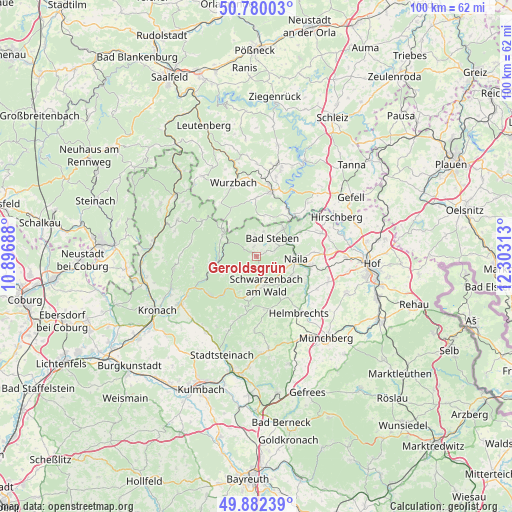
Geroldsgrün GPS coordinates[2]
50° 19' 59.988" North, 11° 36' 0" East
| Map corner | latitude | longitude |
|---|---|---|
| Upper-left | 50.78003°, | 10.89688° |
| Center: | 50.33333°, | 11.6° |
| Lower-right: | 49.88239°, | 12.30313° |
| Map W x H: | 99.8×99.8 km | = 62×62mi |
| max Lat: | 55.01917° ⇑56.1% North |
| Geroldsgrün: | 50.33333° |
| min Lat: | ⇓43.9% South 47.40724° |
| min Long | Geroldsgrün | max Long |
| 5.92978° | 11.6° | 14.98853° |
| W 75.7%⇐ | ⇒24.3% E |
Elevation
Elevation of Geroldsgrün is 618 m = 2028 ft, and this is 368.9 m = 1210 ft above average elevation for this country.
| Max E: |
1256 m = 4121 ft | 4.2% |
| Geroldsgrün | 618 m 2028 ft | |
| Avg. | 249.1 m = 817 ft | |
Min E: |
-5 m = -16 ft | 95.8% |
See also: Germany elevation on elevation.city.
Geographical zone
Geroldsgrün is located in North temperate zone (between Tropic of Cancer and the Arctic Circle). Distance of this North polar circle is 1804.6 km =1121.3 mi to North.| Distance of | km | miles | from Geroldsgrün |
|---|---|---|---|
| North Pole | 4410.5 | 2740.6 | to North |
| Arctic Circle | 1804.6 | 1121.3 | to North |
| Tropic Cancer | 2990.6 | 1858.3 | to South |
| Equator | 5596.5 | 3477.5 | to South |


Nearby cities:
15 places around Geroldsgrün: (largest is in red/bold)
• Bad Steben
4.8 km =3 mi,  40°
40°
• Blankenberg
11.3 km =7 mi,  46°
46°
• Blankenstein
10.4 km =6.5 mi, 42°
• Harra
11 km =6.8 mi,  32°
32°
• Issigau
9.7 km =6 mi,  61°
61°
• Kunreuth
12.2 km =7.6 mi,  203°
203°
• Lichtenberg
7.8 km =4.8 mi, 44°
• Naila
7.4 km =4.6 mi,  92°
92°
• Nordhalben
7.8 km =4.8 mi,  305°
305°
• Presseck
12.1 km =7.5 mi, 195°
• Schauenstein
11.8 km =7.3 mi,  121°
121°
• Schlegel
7.5 km =4.7 mi,  9°
9°
• Selbitz
10.8 km =6.7 mi,  99°
99°
• Steinwiesen
10.6 km =6.6 mi,  246°
246°
• Wallenfels
11.7 km =7.3 mi,  231°
231°
Sources, notices
• [Note1] Compared only with cities in Germany existing in our database
• [Src1] Map data: © OpenStreetMap contributors (CC-BY-SA)
• [Src2] Other city data from geonames.org with taken over terms of usage.
• [Src3] Geographical zone / Annual Mean Temperature by Robert A. Rohde @ Wikipedia
