Schneverdingen geodata
Schneverdingen (Lower Saxony) is a populated place; located in Germany in Europe/Berlin (GMT+2) time zone. With population of 19,199 people, there are 814 cities with bigger population in this country. Compared to other cities in Germany, 82.4% of cities are located further ↓South; 52.9% of cities are located further →East and 69% of cities have higher elevation than Schneverdingen. Note1
Administrative division(s):
- Level 1: Lower Saxony
- Level 3: Landkreis Heidekreis
- Level 4: Schneverdingen


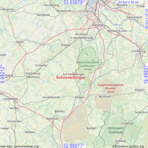
Schneverdingen GPS coordinates[2]
53° 7' 0.66" North, 9° 47' 42.864" East
| Map corner | latitude | longitude |
|---|---|---|
| Upper-left | 53.53679°, | 9.09212° |
| Center: | 53.11685°, | 9.79524° |
| Lower-right: | 52.69277°, | 10.49837° |
| Map W x H: | 93.8×93.8 km | = 58.3×58.3mi |
| max Lat: | 55.01917° ⇑17.6% North |
| Schneverdingen: | 53.11685° |
| min Lat: | ⇓82.4% South 47.40724° |
| min Long | Schneverdingen | max Long |
| 5.92978° | 9.79524° | 14.98853° |
| W 47.1%⇐ | ⇒52.9% E |
Elevation
Elevation of Schneverdingen is 97 m = 318 ft, and this is 152.1 m = 499 ft below average elevation for this country.
| Max E: |
1256 m = 4121 ft | 69% |
| Avg. | 249.1 m = 817 ft | |
| Schneverdingen | 97 m = 318 ft | |
Min E: |
-5 m = -16 ft | 31% |
See also: Germany elevation on elevation.city.
Geographical zone
Schneverdingen is located in North temperate zone (between Tropic of Cancer and the Arctic Circle). Distance of this North polar circle is 1495.1 km =929 mi to North.| Distance of | km | miles | from Schneverdingen |
|---|---|---|---|
| North Pole | 4101 | 2548.2 | to North |
| Arctic Circle | 1495.1 | 929 | to North |
| Tropic Cancer | 3300.1 | 2050.6 | to South |
| Equator | 5906 | 3669.8 | to South |


Nearby cities:
15 places around Schneverdingen: (largest is in red/bold)
• Bispingen
14 km =8.7 mi,  105°
105°
• Brockel
18.7 km =11.6 mi,  264°
264°
• Fintel
10.4 km =6.5 mi,  306°
306°
• Handeloh
14.6 km =9.1 mi,  11°
11°
• Hemslingen
13.6 km =8.5 mi,  254°
254°
• Königsmoor
14.4 km =8.9 mi,  327°
327°
• Lauenbrück
17.8 km =11.1 mi,  301°
301°
• Neuenkirchen
11.1 km =6.9 mi,  212°
212°
• Otter
14.2 km =8.8 mi,  345°
345°
• Soltau
14.9 km =9.3 mi,  167°
167°
• Tostedt
19.2 km =11.9 mi,  344°
344°
• Undeloh
15 km =9.3 mi,  53°
53°
• Vahlde
13.3 km =8.3 mi, 304°
• Welle
13.7 km =8.5 mi,  1°
1°
• Wistedt
18.3 km =11.4 mi, 335°
Sources, notices
• [Note1] Compared only with cities in Germany existing in our database
• [Src1] Map data: © OpenStreetMap contributors (CC-BY-SA)
• [Src2] Other city data from geonames.org with taken over terms of usage.
• [Src3] Geographical zone / Annual Mean Temperature by Robert A. Rohde @ Wikipedia
