Birkenfeld geodata
Birkenfeld (Baden-Württemberg) is a seat of a fourth-order administrative division; located in Germany in Europe/Berlin (GMT+2) time zone. With population of 10,609 people, there are 1558 cities with bigger population in this country. Compared to other cities in Germany, 84.5% of cities are located further ↑North; 69.8% of cities are located further →East and 73% of cities have lower elevation than Birkenfeld. Note1
Administrative division(s):
- Level 1: Baden-Württemberg
- Level 2: Karlsruhe Region
- Level 3: Enzkreis
- Level 4: Birkenfeld


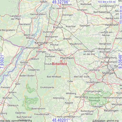
Birkenfeld GPS coordinates[2]
48° 52' 0.012" North, 8° 37' 59.988" East
| Map corner | latitude | longitude |
|---|---|---|
| Upper-left | 49.32706°, | 7.93021° |
| Center: | 48.86667°, | 8.63333° |
| Lower-right: | 48.40201°, | 9.33646° |
| Map W x H: | 102.9×102.9 km | = 63.9×63.9mi |
| max Lat: | 55.01917° ⇑84.5% North |
| Birkenfeld: | 48.86667° |
| min Lat: | ⇓15.5% South 47.40724° |
| min Long | Birkenfeld | max Long |
| 5.92978° | 8.63333° | 14.98853° |
| W 30.2%⇐ | ⇒69.8% E |
Elevation
Elevation of Birkenfeld is 382 m = 1253 ft, and this is 132.9 m = 436 ft above average elevation for this country.
| Max E: |
1256 m = 4121 ft | 27% |
| Birkenfeld | 382 m 1253 ft | |
| Avg. | 249.1 m = 817 ft | |
Min E: |
-5 m = -16 ft | 73% |
See also: Germany elevation on elevation.city.
Geographical zone
Birkenfeld is located in North temperate zone (between Tropic of Cancer and the Arctic Circle). Distance of this North polar circle is 1967.7 km =1222.7 mi to North.| Distance of | km | miles | from Birkenfeld |
|---|---|---|---|
| North Pole | 4573.6 | 2841.9 | to North |
| Arctic Circle | 1967.7 | 1222.7 | to North |
| Tropic Cancer | 2827.5 | 1756.9 | to South |
| Equator | 5433.5 | 3376.2 | to South |


Nearby cities:
15 places around Birkenfeld: (largest is in red/bold)
• Bad Liebenzell
12.5 km =7.8 mi,  145°
145°
• Dobel
12.3 km =7.6 mi,  232°
232°
• Eisingen
9.6 km =6 mi,  14°
14°
• Engelsbrand
3.9 km =2.4 mi,  161°
161°
• Eutingen an der Enz
9.9 km =6.2 mi,  58°
58°
• Höfen an der Enz
8.3 km =5.2 mi,  206°
206°
• Ispringen
6.1 km =3.8 mi,  23°
23°
• Kieselbronn
11.3 km =7 mi,  49°
49°
• Königsbach-Stein
11.2 km =7 mi,  349°
349°
• Neuenbürg
3.6 km =2.2 mi, 228°
• Niefern-Öschelbronn
12.3 km =7.6 mi, 63°
• Pforzheim
5.2 km =3.2 mi,  67°
67°
• Schömberg
8.9 km =5.5 mi,  174°
174°
• Tiefenbronn
13.2 km =8.2 mi,  111°
111°
• Unterreichenbach
7.2 km =4.5 mi,  130°
130°
Sources, notices
• [Note1] Compared only with cities in Germany existing in our database
• [Src1] Map data: © OpenStreetMap contributors (CC-BY-SA)
• [Src2] Other city data from geonames.org with taken over terms of usage.
• [Src3] Geographical zone / Annual Mean Temperature by Robert A. Rohde @ Wikipedia
