Engelsbrand geodata
Engelsbrand (Baden-Württemberg) is a seat of a fourth-order administrative division; located in Germany in Europe/Berlin (GMT+2) time zone. With population of 4,361 people, there are 3107 cities with bigger population in this country. Compared to other cities in Germany, 84.9% of cities are located further ↑North; 69.6% of cities are located further →East and 94.1% of cities have lower elevation than Engelsbrand. Note1
Administrative division(s):
- Level 1: Baden-Württemberg
- Level 2: Karlsruhe Region
- Level 3: Enzkreis
- Level 4: Engelsbrand


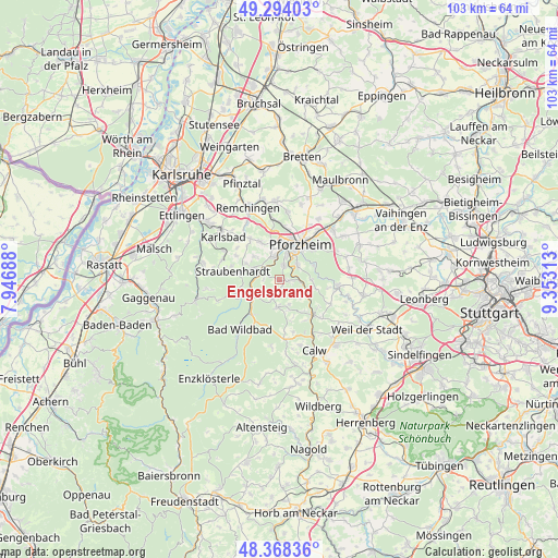
Engelsbrand GPS coordinates[2]
48° 49' 59.988" North, 8° 39' 0" East
| Map corner | latitude | longitude |
|---|---|---|
| Upper-left | 49.29403°, | 7.94688° |
| Center: | 48.83333°, | 8.65° |
| Lower-right: | 48.36836°, | 9.35313° |
| Map W x H: | 102.9×102.9 km | = 63.9×63.9mi |
| max Lat: | 55.01917° ⇑84.9% North |
| Engelsbrand: | 48.83333° |
| min Lat: | ⇓15.1% South 47.40724° |
| min Long | Engelsbrand | max Long |
| 5.92978° | 8.65° | 14.98853° |
| W 30.4%⇐ | ⇒69.6% E |
Elevation
Elevation of Engelsbrand is 576 m = 1890 ft, and this is 326.9 m = 1073 ft above average elevation for this country.
| Max E: |
1256 m = 4121 ft | 5.9% |
| Engelsbrand | 576 m 1890 ft | |
| Avg. | 249.1 m = 817 ft | |
Min E: |
-5 m = -16 ft | 94.1% |
See also: Germany elevation on elevation.city.
Geographical zone
Engelsbrand is located in North temperate zone (between Tropic of Cancer and the Arctic Circle). Distance of this North polar circle is 1971.4 km =1225 mi to North.| Distance of | km | miles | from Engelsbrand |
|---|---|---|---|
| North Pole | 4577.3 | 2844.2 | to North |
| Arctic Circle | 1971.4 | 1225 | to North |
| Tropic Cancer | 2823.8 | 1754.6 | to South |
| Equator | 5429.8 | 3373.9 | to South |


Nearby cities:
15 places around Engelsbrand: (largest is in red/bold)
• Bad Liebenzell
8.8 km =5.5 mi,  138°
138°
• Bad Wildbad
11.7 km =7.3 mi,  218°
218°
• Birkenfeld
3.9 km =2.4 mi,  341°
341°
• Dobel
11.6 km =7.2 mi,  251°
251°
• Eutingen an der Enz
11.4 km =7.1 mi,  39°
39°
• Höfen an der Enz
6.1 km =3.8 mi,  232°
232°
• Ispringen
9.3 km =5.8 mi,  7°
7°
• Neuenbürg
4.2 km =2.6 mi,  288°
288°
• Neuhausen
10.3 km =6.4 mi,  116°
116°
• Oberreichenbach
11.2 km =7 mi,  173°
173°
• Pforzheim
6.7 km =4.2 mi,  32°
32°
• Schömberg
5.2 km =3.2 mi,  184°
184°
• Tiefenbronn
11.1 km =6.9 mi,  95°
95°
• Unterreichenbach
4.4 km =2.7 mi, 102°
• Wurmberg
12.7 km =7.9 mi,  73°
73°
Sources, notices
• [Note1] Compared only with cities in Germany existing in our database
• [Src1] Map data: © OpenStreetMap contributors (CC-BY-SA)
• [Src2] Other city data from geonames.org with taken over terms of usage.
• [Src3] Geographical zone / Annual Mean Temperature by Robert A. Rohde @ Wikipedia
