Schömberg geodata
Schömberg (Baden-Württemberg) is a seat of a fourth-order administrative division; located in Germany in Europe/Berlin (GMT+2) time zone. With population of 8,725 people, there are 1840 cities with bigger population in this country. Compared to other cities in Germany, 85.5% of cities are located further ↑North; 69.7% of cities are located further →East and 96% of cities have lower elevation than Schömberg. Note1
Administrative division(s):
- Level 1: Baden-Württemberg
- Level 2: Karlsruhe Region
- Level 3: Landkreis Calw
- Level 4: Schömberg


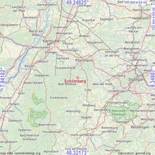
Schömberg GPS coordinates[2]
48° 47' 13.668" North, 8° 38' 41.82" East
| Map corner | latitude | longitude |
|---|---|---|
| Upper-left | 49.24825°, | 7.94182° |
| Center: | 48.78713°, | 8.64495° |
| Lower-right: | 48.32173°, | 9.34807° |
| Map W x H: | 103×103 km | = 64×64mi |
| max Lat: | 55.01917° ⇑85.5% North |
| Schömberg: | 48.78713° |
| min Lat: | ⇓14.5% South 47.40724° |
| min Long | Schömberg | max Long |
| 5.92978° | 8.64495° | 14.98853° |
| W 30.3%⇐ | ⇒69.7% E |
Elevation
Elevation of Schömberg is 629 m = 2064 ft, and this is 379.9 m = 1246 ft above average elevation for this country.
| Max E: |
1256 m = 4121 ft | 4% |
| Schömberg | 629 m 2064 ft | |
| Avg. | 249.1 m = 817 ft | |
Min E: |
-5 m = -16 ft | 96% |
See also: Germany elevation on elevation.city.
Geographical zone
Schömberg is located in North temperate zone (between Tropic of Cancer and the Arctic Circle). Distance of this North polar circle is 1976.6 km =1228.2 mi to North.| Distance of | km | miles | from Schömberg |
|---|---|---|---|
| North Pole | 4582.4 | 2847.4 | to North |
| Arctic Circle | 1976.6 | 1228.2 | to North |
| Tropic Cancer | 2818.7 | 1751.5 | to South |
| Equator | 5424.6 | 3370.7 | to South |


Nearby cities:
15 places around Schömberg: (largest is in red/bold)
• Bad Liebenzell
6.4 km =4 mi,  102°
102°
• Bad Teinach-Zavelstein
11.3 km =7 mi,  161°
161°
• Bad Wildbad
8 km =5 mi,  239°
239°
• Birkenfeld
8.9 km =5.5 mi,  354°
354°
• Calw
10.7 km =6.6 mi,  139°
139°
• Dobel
10.7 km =6.6 mi,  277°
277°
• Engelsbrand
5.2 km =3.2 mi,  4°
4°
• Höfen an der Enz
4.7 km =2.9 mi,  287°
287°
• Neuenbürg
7.4 km =4.6 mi,  330°
330°
• Neuhausen
9.7 km =6 mi,  86°
86°
• Oberreichenbach
6.2 km =3.9 mi,  165°
165°
• Pforzheim
11.5 km =7.1 mi,  20°
20°
• Simmozheim
12.8 km =8 mi,  108°
108°
• Tiefenbronn
12.2 km =7.6 mi,  70°
70°
• Unterreichenbach
6.3 km =3.9 mi,  48°
48°
Sources, notices
• [Note1] Compared only with cities in Germany existing in our database
• [Src1] Map data: © OpenStreetMap contributors (CC-BY-SA)
• [Src2] Other city data from geonames.org with taken over terms of usage.
• [Src3] Geographical zone / Annual Mean Temperature by Robert A. Rohde @ Wikipedia
