Neuenbürg geodata
Neuenbürg (Baden-Württemberg) is a populated place; located in Germany in Europe/Berlin (GMT+2) time zone. With population of 7,780 people, there are 1993 cities with bigger population in this country. Compared to other cities in Germany, 84.8% of cities are located further ↑North; 70.2% of cities are located further →East and 65.7% of cities have lower elevation than Neuenbürg. Note1
Administrative division(s):
- Level 1: Baden-Württemberg
- Level 2: Karlsruhe Region
- Level 3: Enzkreis
- Level 4: Neuenbürg


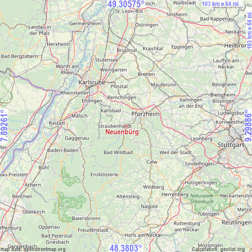
Neuenbürg GPS coordinates[2]
48° 50' 42.576" North, 8° 35' 44.664" East
| Map corner | latitude | longitude |
|---|---|---|
| Upper-left | 49.30575°, | 7.89261° |
| Center: | 48.84516°, | 8.59574° |
| Lower-right: | 48.3803°, | 9.29886° |
| Map W x H: | 102.9×102.9 km | = 63.9×63.9mi |
| max Lat: | 55.01917° ⇑84.8% North |
| Neuenbürg: | 48.84516° |
| min Lat: | ⇓15.2% South 47.40724° |
| min Long | Neuenbürg | max Long |
| 5.92978° | 8.59574° | 14.98853° |
| W 29.8%⇐ | ⇒70.2% E |
Elevation
Elevation of Neuenbürg is 326 m = 1070 ft, and this is 76.9 m = 252 ft above average elevation for this country.
| Max E: |
1256 m = 4121 ft | 34.3% |
| Neuenbürg | 326 m 1070 ft | |
| Avg. | 249.1 m = 817 ft | |
Min E: |
-5 m = -16 ft | 65.7% |
See also: Germany elevation on elevation.city.
Geographical zone
Neuenbürg is located in North temperate zone (between Tropic of Cancer and the Arctic Circle). Distance of this North polar circle is 1970.1 km =1224.2 mi to North.| Distance of | km | miles | from Neuenbürg |
|---|---|---|---|
| North Pole | 4576 | 2843.4 | to North |
| Arctic Circle | 1970.1 | 1224.2 | to North |
| Tropic Cancer | 2825.2 | 1755.5 | to South |
| Equator | 5431.1 | 3374.7 | to South |


Nearby cities:
15 places around Neuenbürg: (largest is in red/bold)
• Bad Herrenalb
12.8 km =8 mi,  245°
245°
• Bad Liebenzell
12.6 km =7.8 mi,  128°
128°
• Bad Wildbad
11 km =6.8 mi,  197°
197°
• Birkenfeld
3.6 km =2.2 mi,  48°
48°
• Dobel
8.6 km =5.3 mi,  234°
234°
• Eisingen
12.8 km =8 mi,  23°
23°
• Engelsbrand
4.2 km =2.6 mi,  108°
108°
• Eutingen an der Enz
13.5 km =8.4 mi,  56°
56°
• Höfen an der Enz
5.1 km =3.2 mi,  190°
190°
• Ispringen
9.5 km =5.9 mi,  33°
33°
• Königsbach-Stein
13.4 km =8.3 mi,  3°
3°
• Oberreichenbach
13.5 km =8.4 mi,  157°
157°
• Pforzheim
8.7 km =5.4 mi, 59°
• Schömberg
7.4 km =4.6 mi,  150°
150°
• Unterreichenbach
8.6 km =5.3 mi, 105°
Sources, notices
• [Note1] Compared only with cities in Germany existing in our database
• [Src1] Map data: © OpenStreetMap contributors (CC-BY-SA)
• [Src2] Other city data from geonames.org with taken over terms of usage.
• [Src3] Geographical zone / Annual Mean Temperature by Robert A. Rohde @ Wikipedia
