Unterreichenbach geodata
Unterreichenbach (Baden-Württemberg) is a seat of a fourth-order administrative division; located in Germany in Europe/Berlin (GMT+2) time zone. With population of 2,282 people, there are 4699 cities with bigger population in this country. Compared to other cities in Germany, 85% of cities are located further ↑North; 68.9% of cities are located further →East and 63.3% of cities have lower elevation than Unterreichenbach. Note1
Administrative division(s):
- Level 1: Baden-Württemberg
- Level 2: Karlsruhe Region
- Level 3: Landkreis Calw
- Level 4: Unterreichenbach


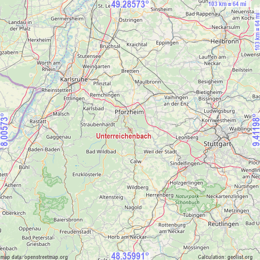
Unterreichenbach GPS coordinates[2]
48° 49' 29.856" North, 8° 42' 31.86" East
| Map corner | latitude | longitude |
|---|---|---|
| Upper-left | 49.28573°, | 8.00573° |
| Center: | 48.82496°, | 8.70885° |
| Lower-right: | 48.35991°, | 9.41198° |
| Map W x H: | 102.9×102.9 km | = 63.9×63.9mi |
| max Lat: | 55.01917° ⇑85% North |
| Unterreichenbach: | 48.82496° |
| min Lat: | ⇓15% South 47.40724° |
| min Long | Unterreichenbac | max Long |
| 5.92978° | 8.70885° | 14.98853° |
| W 31.1%⇐ | ⇒68.9% E |
Elevation
Elevation of Unterreichenbach is 310 m = 1017 ft, and this is 60.9 m = 200 ft above average elevation for this country.
| Max E: |
1256 m = 4121 ft | 36.7% |
| Unterreichenbach | 310 m 1017 ft | |
| Avg. | 249.1 m = 817 ft | |
Min E: |
-5 m = -16 ft | 63.3% |
See also: Germany elevation on elevation.city.
Geographical zone
Unterreichenbach is located in North temperate zone (between Tropic of Cancer and the Arctic Circle). Distance of this North polar circle is 1972.3 km =1225.5 mi to North.| Distance of | km | miles | from Unterreichenbach |
|---|---|---|---|
| North Pole | 4578.2 | 2844.8 | to North |
| Arctic Circle | 1972.3 | 1225.5 | to North |
| Tropic Cancer | 2822.9 | 1754.1 | to South |
| Equator | 5428.8 | 3373.3 | to South |


Nearby cities:
15 places around Unterreichenbach: (largest is in red/bold)
• Bad Liebenzell
5.8 km =3.6 mi,  164°
164°
• Birkenfeld
7.2 km =4.5 mi,  310°
310°
• Engelsbrand
4.4 km =2.7 mi,  282°
282°
• Eutingen an der Enz
10.2 km =6.3 mi,  16°
16°
• Friolzheim
9.2 km =5.7 mi,  84°
84°
• Höfen an der Enz
9.6 km =6 mi,  253°
253°
• Ispringen
10.7 km =6.6 mi,  343°
343°
• Neuenbürg
8.6 km =5.3 mi,  285°
285°
• Neuhausen
6.1 km =3.8 mi,  125°
125°
• Oberreichenbach
10.6 km =6.6 mi,  196°
196°
• Pforzheim
6.6 km =4.1 mi,  353°
353°
• Schömberg
6.3 km =3.9 mi,  228°
228°
• Tiefenbronn
6.8 km =4.2 mi,  90°
90°
• Wimsheim
9.5 km =5.9 mi,  73°
73°
• Wurmberg
9.2 km =5.7 mi,  59°
59°
Sources, notices
• [Note1] Compared only with cities in Germany existing in our database
• [Src1] Map data: © OpenStreetMap contributors (CC-BY-SA)
• [Src2] Other city data from geonames.org with taken over terms of usage.
• [Src3] Geographical zone / Annual Mean Temperature by Robert A. Rohde @ Wikipedia
