Bad Bevensen geodata
Bad Bevensen (Lower Saxony) is a populated place; located in Germany in Europe/Berlin (GMT+2) time zone. With population of 8,700 people, there are 1843 cities with bigger population in this country. Compared to other cities in Germany, 82.2% of cities are located further ↓South; 60.3% of cities are located further ←West and 85.4% of cities have higher elevation than Bad Bevensen. Note1


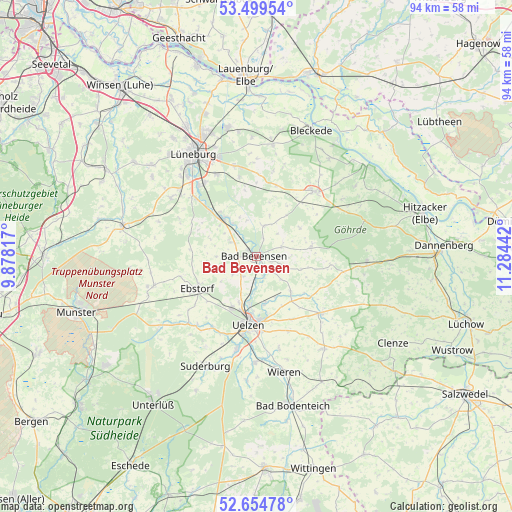
Bad Bevensen GPS coordinates[2]
53° 4' 45.228" North, 10° 34' 52.644" East
| Map corner | latitude | longitude |
|---|---|---|
| Upper-left | 53.49954°, | 9.87817° |
| Center: | 53.07923°, | 10.58129° |
| Lower-right: | 52.65478°, | 11.28442° |
| Map W x H: | 93.9×93.9 km | = 58.3×58.3mi |
| max Lat: | 55.01917° ⇑17.8% North |
| Bad Bevensen: | 53.07923° |
| min Lat: | ⇓82.2% South 47.40724° |
| min Long | Bad Bevensen | max Long |
| 5.92978° | 10.58129° | 14.98853° |
| W 60.3%⇐ | ⇒39.7% E |
Elevation
Elevation of Bad Bevensen is 34 m = 112 ft, and this is 215.1 m = 706 ft below average elevation for this country.
| Max E: |
1256 m = 4121 ft | 85.4% |
| Avg. | 249.1 m = 817 ft | |
| Bad Bevensen | 34 m = 112 ft | |
Min E: |
-5 m = -16 ft | 14.6% |
See also: Germany elevation on elevation.city.
Geographical zone
Bad Bevensen is located in North temperate zone (between Tropic of Cancer and the Arctic Circle). Distance of this North polar circle is 1499.3 km =931.6 mi to North.| Distance of | km | miles | from Bad Bevensen |
|---|---|---|---|
| North Pole | 4105.2 | 2550.9 | to North |
| Arctic Circle | 1499.3 | 931.6 | to North |
| Tropic Cancer | 3295.9 | 2048 | to South |
| Equator | 5901.9 | 3667.3 | to South |


Nearby cities:
15 places around Bad Bevensen: (largest is in red/bold)
• Altenmedingen
5.9 km =3.7 mi,  13°
13°
• Barum
5.4 km =3.4 mi,  233°
233°
• Bienenbüttel
9.4 km =5.8 mi,  317°
317°
• Ebstorf
12.3 km =7.6 mi,  242°
242°
• Emmendorf
6.7 km =4.2 mi,  189°
189°
• Himbergen
10 km =6.2 mi,  80°
80°
• Jelmstorf
4.6 km =2.9 mi,  301°
301°
• Natendorf
7.4 km =4.6 mi,  270°
270°
• Oetzen
9.2 km =5.7 mi,  136°
136°
• Rätzlingen
13.1 km =8.1 mi,  151°
151°
• Römstedt
5.1 km =3.2 mi,  63°
63°
• Schwienau
12.2 km =7.6 mi, 227°
• Uelzen
12.7 km =7.9 mi, 186°
• Vastorf
13.4 km =8.3 mi,  349°
349°
• Weste
8.4 km =5.2 mi,  105°
105°
Sources, notices
• [Note1] Compared only with cities in Germany existing in our database
• [Src1] Map data: © OpenStreetMap contributors (CC-BY-SA)
• [Src2] Other city data from geonames.org with taken over terms of usage.
• [Src3] Geographical zone / Annual Mean Temperature by Robert A. Rohde @ Wikipedia
