Schwienau geodata
Schwienau (Lower Saxony) is a seat of a fourth-order administrative division; located in Germany in Europe/Berlin (GMT+2) time zone. With population of 742 people, there are 8140 cities with bigger population in this country. Compared to other cities in Germany, 81.8% of cities are located further ↓South; 58% of cities are located further ←West and 73.2% of cities have higher elevation than Schwienau. Note1


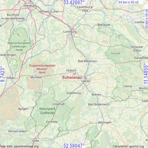
Schwienau GPS coordinates[2]
53° 0' 20.304" North, 10° 26' 43.512" East
| Map corner | latitude | longitude |
|---|---|---|
| Upper-left | 53.42667°, | 9.7423° |
| Center: | 53.00564°, | 10.44542° |
| Lower-right: | 52.58047°, | 11.14855° |
| Map W x H: | 94.1×94.1 km | = 58.5×58.5mi |
| max Lat: | 55.01917° ⇑18.2% North |
| Schwienau: | 53.00564° |
| min Lat: | ⇓81.8% South 47.40724° |
| min Long | Schwienau | max Long |
| 5.92978° | 10.44542° | 14.98853° |
| W 58%⇐ | ⇒42% E |
Elevation
Elevation of Schwienau is 71 m = 233 ft, and this is 178.1 m = 584 ft below average elevation for this country.
| Max E: |
1256 m = 4121 ft | 73.2% |
| Avg. | 249.1 m = 817 ft | |
| Schwienau | 71 m = 233 ft | |
Min E: |
-5 m = -16 ft | 26.8% |
See also: Germany elevation on elevation.city.
Geographical zone
Schwienau is located in North temperate zone (between Tropic of Cancer and the Arctic Circle). Distance of this North polar circle is 1507.5 km =936.7 mi to North.| Distance of | km | miles | from Schwienau |
|---|---|---|---|
| North Pole | 4113.4 | 2555.9 | to North |
| Arctic Circle | 1507.5 | 936.7 | to North |
| Tropic Cancer | 3287.8 | 2042.9 | to South |
| Equator | 5893.7 | 3662.2 | to South |


Nearby cities:
15 places around Schwienau: (largest is in red/bold)
• Bad Bevensen
12.2 km =7.6 mi,  47°
47°
• Barnstedt
15.1 km =9.4 mi,  339°
339°
• Barum
6.9 km =4.3 mi,  44°
44°
• Bienenbüttel
15.4 km =9.6 mi,  10°
10°
• Ebstorf
3.1 km =1.9 mi,  323°
323°
• Eimke
9.9 km =6.2 mi,  243°
243°
• Emmendorf
8.1 km =5 mi,  78°
78°
• Gerdau
4.7 km =2.9 mi,  203°
203°
• Hanstedt Eins
6.6 km =4.1 mi,  313°
313°
• Jelmstorf
11.8 km =7.3 mi,  25°
25°
• Natendorf
8.4 km =5.2 mi, 11°
• Suderburg
12.2 km =7.6 mi,  178°
178°
• Uelzen
8.9 km =5.5 mi,  119°
119°
• Wrestedt
14.2 km =8.8 mi,  142°
142°
• Wriedel
10.2 km =6.3 mi,  286°
286°
Sources, notices
• [Note1] Compared only with cities in Germany existing in our database
• [Src1] Map data: © OpenStreetMap contributors (CC-BY-SA)
• [Src2] Other city data from geonames.org with taken over terms of usage.
• [Src3] Geographical zone / Annual Mean Temperature by Robert A. Rohde @ Wikipedia
