Jelmstorf geodata
Jelmstorf (Lower Saxony) is a seat of a fourth-order administrative division; located in Germany in Europe/Berlin (GMT+2) time zone. With population of 853 people, there are 7690 cities with bigger population in this country. Compared to other cities in Germany, 82.3% of cities are located further ↓South; 59.3% of cities are located further ←West and 79.4% of cities have higher elevation than Jelmstorf. Note1


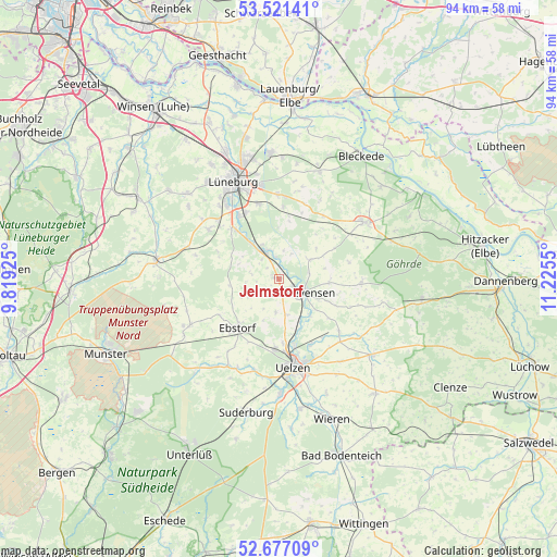
Jelmstorf GPS coordinates[2]
53° 6' 4.752" North, 10° 31' 20.532" East
| Map corner | latitude | longitude |
|---|---|---|
| Upper-left | 53.52141°, | 9.81925° |
| Center: | 53.10132°, | 10.52237° |
| Lower-right: | 52.67709°, | 11.2255° |
| Map W x H: | 93.9×93.9 km | = 58.3×58.3mi |
| max Lat: | 55.01917° ⇑17.7% North |
| Jelmstorf: | 53.10132° |
| min Lat: | ⇓82.3% South 47.40724° |
| min Long | Jelmstorf | max Long |
| 5.92978° | 10.52237° | 14.98853° |
| W 59.3%⇐ | ⇒40.7% E |
Elevation
Elevation of Jelmstorf is 48 m = 157 ft, and this is 201.1 m = 660 ft below average elevation for this country.
| Max E: |
1256 m = 4121 ft | 79.4% |
| Avg. | 249.1 m = 817 ft | |
| Jelmstorf | 48 m = 157 ft | |
Min E: |
-5 m = -16 ft | 20.6% |
See also: Germany elevation on elevation.city.
Geographical zone
Jelmstorf is located in North temperate zone (between Tropic of Cancer and the Arctic Circle). Distance of this North polar circle is 1496.9 km =930.1 mi to North.| Distance of | km | miles | from Jelmstorf |
|---|---|---|---|
| North Pole | 4102.7 | 2549.3 | to North |
| Arctic Circle | 1496.9 | 930.1 | to North |
| Tropic Cancer | 3298.4 | 2049.5 | to South |
| Equator | 5904.3 | 3668.8 | to South |


Nearby cities:
15 places around Jelmstorf: (largest is in red/bold)
• Altenmedingen
6.2 km =3.9 mi,  58°
58°
• Bad Bevensen
4.6 km =2.9 mi,  121°
121°
• Barnstedt
11 km =6.8 mi,  288°
288°
• Barum
5.7 km =3.5 mi,  183°
183°
• Bienenbüttel
5.1 km =3.2 mi,  332°
332°
• Deutsch Evern
12.5 km =7.8 mi, 331°
• Ebstorf
10.7 km =6.6 mi,  220°
220°
• Emmendorf
9.4 km =5.8 mi,  162°
162°
• Hanstedt Eins
11.6 km =7.2 mi,  238°
238°
• Melbeck
12.2 km =7.6 mi,  318°
318°
• Natendorf
4.2 km =2.6 mi, 235°
• Römstedt
8.5 km =5.3 mi,  90°
90°
• Schwienau
11.8 km =7.3 mi,  205°
205°
• Vastorf
10.9 km =6.8 mi,  8°
8°
• Weste
12.9 km =8 mi,  111°
111°
Sources, notices
• [Note1] Compared only with cities in Germany existing in our database
• [Src1] Map data: © OpenStreetMap contributors (CC-BY-SA)
• [Src2] Other city data from geonames.org with taken over terms of usage.
• [Src3] Geographical zone / Annual Mean Temperature by Robert A. Rohde @ Wikipedia
