Emmendorf geodata
Emmendorf (Lower Saxony) is a seat of a fourth-order administrative division; located in Germany in Europe/Berlin (GMT+2) time zone. With population of 788 people, there are 7952 cities with bigger population in this country. Compared to other cities in Germany, 81.9% of cities are located further ↓South; 60.1% of cities are located further ←West and 82.3% of cities have higher elevation than Emmendorf. Note1


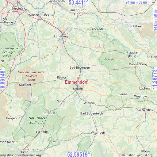
Emmendorf GPS coordinates[2]
53° 1' 12.792" North, 10° 33' 52.56" East
| Map corner | latitude | longitude |
|---|---|---|
| Upper-left | 53.4411°, | 9.86148° |
| Center: | 53.02022°, | 10.5646° |
| Lower-right: | 52.59519°, | 11.26773° |
| Map W x H: | 94.1×94.1 km | = 58.5×58.5mi |
| max Lat: | 55.01917° ⇑18.1% North |
| Emmendorf: | 53.02022° |
| min Lat: | ⇓81.9% South 47.40724° |
| min Long | Emmendorf | max Long |
| 5.92978° | 10.5646° | 14.98853° |
| W 60.1%⇐ | ⇒39.9% E |
Elevation
Elevation of Emmendorf is 41 m = 135 ft, and this is 208.1 m = 683 ft below average elevation for this country.
| Max E: |
1256 m = 4121 ft | 82.3% |
| Avg. | 249.1 m = 817 ft | |
| Emmendorf | 41 m = 135 ft | |
Min E: |
-5 m = -16 ft | 17.7% |
See also: Germany elevation on elevation.city.
Geographical zone
Emmendorf is located in North temperate zone (between Tropic of Cancer and the Arctic Circle). Distance of this North polar circle is 1505.9 km =935.7 mi to North.| Distance of | km | miles | from Emmendorf |
|---|---|---|---|
| North Pole | 4111.8 | 2555 | to North |
| Arctic Circle | 1505.9 | 935.7 | to North |
| Tropic Cancer | 3289.4 | 2043.9 | to South |
| Equator | 5895.3 | 3663.2 | to South |


Nearby cities:
15 places around Emmendorf: (largest is in red/bold)
• Altenmedingen
12.5 km =7.8 mi,  11°
11°
• Bad Bevensen
6.7 km =4.2 mi, 9°
• Barum
4.6 km =2.9 mi,  315°
315°
• Ebstorf
9.8 km =6.1 mi,  274°
274°
• Gerdau
11.6 km =7.2 mi,  238°
238°
• Hanstedt Eins
13 km =8.1 mi,  282°
282°
• Jelmstorf
9.4 km =5.8 mi,  342°
342°
• Natendorf
9.1 km =5.7 mi, 316°
• Oetzen
7.4 km =4.6 mi,  90°
90°
• Rätzlingen
8.9 km =5.5 mi,  123°
123°
• Römstedt
10.5 km =6.5 mi,  32°
32°
• Schwienau
8.1 km =5 mi,  258°
258°
• Uelzen
6.1 km =3.8 mi,  182°
182°
• Weste
10.2 km =6.3 mi,  64°
64°
• Wrestedt
12.9 km =8 mi, 176°
Sources, notices
• [Note1] Compared only with cities in Germany existing in our database
• [Src1] Map data: © OpenStreetMap contributors (CC-BY-SA)
• [Src2] Other city data from geonames.org with taken over terms of usage.
• [Src3] Geographical zone / Annual Mean Temperature by Robert A. Rohde @ Wikipedia
