Weste geodata
Weste (Lower Saxony) is a seat of a fourth-order administrative division; located in Germany in Europe/Berlin (GMT+2) time zone. With population of 1,062 people, there are 6958 cities with bigger population in this country. Compared to other cities in Germany, 82.1% of cities are located further ↓South; 62.5% of cities are located further ←West and 76.1% of cities have higher elevation than Weste. Note1


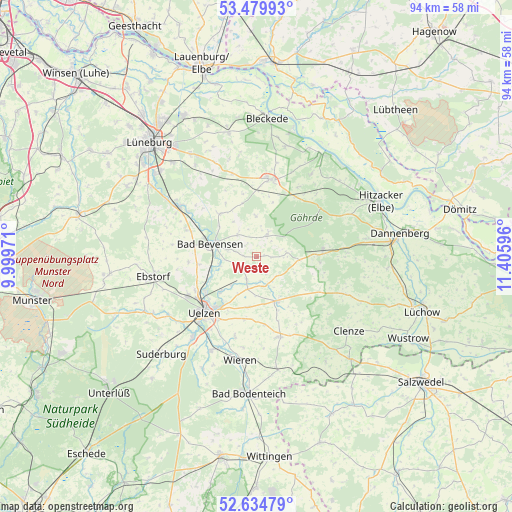
Weste GPS coordinates[2]
53° 3' 33.948" North, 10° 42' 10.188" East
| Map corner | latitude | longitude |
|---|---|---|
| Upper-left | 53.47993°, | 9.99971° |
| Center: | 53.05943°, | 10.70283° |
| Lower-right: | 52.63479°, | 11.40596° |
| Map W x H: | 94×94 km | = 58.4×58.4mi |
| max Lat: | 55.01917° ⇑17.9% North |
| Weste: | 53.05943° |
| min Lat: | ⇓82.1% South 47.40724° |
| min Long | Weste | max Long |
| 5.92978° | 10.70283° | 14.98853° |
| W 62.5%⇐ | ⇒37.5% E |
Elevation
Elevation of Weste is 59 m = 194 ft, and this is 190.1 m = 624 ft below average elevation for this country.
| Max E: |
1256 m = 4121 ft | 76.1% |
| Avg. | 249.1 m = 817 ft | |
| Weste | 59 m = 194 ft | |
Min E: |
-5 m = -16 ft | 23.9% |
See also: Germany elevation on elevation.city.
Geographical zone
Weste is located in North temperate zone (between Tropic of Cancer and the Arctic Circle). Distance of this North polar circle is 1501.5 km =933 mi to North.| Distance of | km | miles | from Weste |
|---|---|---|---|
| North Pole | 4107.4 | 2552.2 | to North |
| Arctic Circle | 1501.5 | 933 | to North |
| Tropic Cancer | 3293.7 | 2046.6 | to South |
| Equator | 5899.7 | 3665.9 | to South |


Nearby cities:
15 places around Weste: (largest is in red/bold)
• Altenmedingen
10.4 km =6.5 mi,  319°
319°
• Bad Bevensen
8.4 km =5.2 mi,  285°
285°
• Barum
12.5 km =7.8 mi,  265°
265°
• Boitze
10.6 km =6.6 mi,  17°
17°
• Dahlenburg
14.4 km =8.9 mi,  8°
8°
• Emmendorf
10.2 km =6.3 mi,  244°
244°
• Himbergen
4.2 km =2.6 mi, 24°
• Jelmstorf
12.9 km =8 mi, 291°
• Oetzen
4.8 km =3 mi,  202°
202°
• Rosche
8.7 km =5.4 mi,  157°
157°
• Rätzlingen
9.5 km =5.9 mi,  191°
191°
• Römstedt
5.7 km =3.5 mi, 321°
• Stoetze
5.4 km =3.4 mi,  81°
81°
• Uelzen
14.1 km =8.8 mi,  222°
222°
• Zernien
12.1 km =7.5 mi,  85°
85°
Sources, notices
• [Note1] Compared only with cities in Germany existing in our database
• [Src1] Map data: © OpenStreetMap contributors (CC-BY-SA)
• [Src2] Other city data from geonames.org with taken over terms of usage.
• [Src3] Geographical zone / Annual Mean Temperature by Robert A. Rohde @ Wikipedia
