Bernsdorf geodata
Bernsdorf (Saxony) is a populated place; located in Germany in Europe/Berlin (GMT+2) time zone. With population of 5,871 people, there are 2501 cities with bigger population in this country. Compared to other cities in Germany, 64.3% of cities are located further ↓South; 98.2% of cities are located further ←West and 60.6% of cities have higher elevation than Bernsdorf. Note1


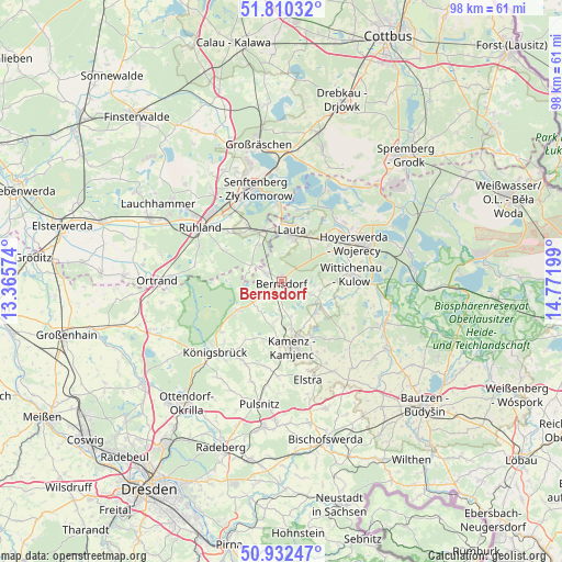
Bernsdorf GPS coordinates[2]
51° 22' 24.6" North, 14° 4' 7.896" East
| Map corner | latitude | longitude |
|---|---|---|
| Upper-left | 51.81032°, | 13.36574° |
| Center: | 51.3735°, | 14.06886° |
| Lower-right: | 50.93247°, | 14.77199° |
| Map W x H: | 97.6×97.6 km | = 60.6×60.6mi |
| max Lat: | 55.01917° ⇑35.7% North |
| Bernsdorf: | 51.3735° |
| min Lat: | ⇓64.3% South 47.40724° |
| min Long | Bernsdorf | max Long |
| 5.92978° | 14.06886° | 14.98853° |
| W 98.2%⇐ | ⇒1.8% E |
Elevation
Elevation of Bernsdorf is 148 m = 486 ft, and this is 101.1 m = 332 ft below average elevation for this country.
| Max E: |
1256 m = 4121 ft | 60.6% |
| Avg. | 249.1 m = 817 ft | |
| Bernsdorf | 148 m = 486 ft | |
Min E: |
-5 m = -16 ft | 39.4% |
See also: Germany elevation on elevation.city.
Geographical zone
Bernsdorf is located in North temperate zone (between Tropic of Cancer and the Arctic Circle). Distance of this North polar circle is 1689 km =1049.5 mi to North.| Distance of | km | miles | from Bernsdorf |
|---|---|---|---|
| North Pole | 4294.9 | 2668.7 | to North |
| Arctic Circle | 1689 | 1049.5 | to North |
| Tropic Cancer | 3106.3 | 1930.2 | to South |
| Equator | 5712.2 | 3549.4 | to South |


Nearby cities:
15 places around Bernsdorf: (largest is in red/bold)
• Grünewald
5.6 km =3.5 mi,  301°
301°
• Guteborn
10.6 km =6.6 mi, 297°
• Haselbachtal
15.6 km =9.7 mi,  191°
191°
• Hermsdorf
12.7 km =7.9 mi,  286°
286°
• Hohenbocka
7.6 km =4.7 mi,  327°
327°
• Hoyerswerda
13.6 km =8.5 mi,  58°
58°
• Kamenz
11.9 km =7.4 mi,  171°
171°
• Nebelschütz
13.8 km =8.6 mi,  153°
153°
• Neukirch
11.7 km =7.3 mi,  210°
210°
• Oßling
6.9 km =4.3 mi,  102°
102°
• Schwarzbach
12.7 km =7.9 mi,  312°
312°
• Schwepnitz
9.2 km =5.7 mi,  236°
236°
• Straßgräbchen
2.4 km =1.5 mi, 188°
• Wiednitz
3.2 km =2 mi, 295°
• Wittichenau
12.2 km =7.6 mi,  84°
84°
Sources, notices
• [Note1] Compared only with cities in Germany existing in our database
• [Src1] Map data: © OpenStreetMap contributors (CC-BY-SA)
• [Src2] Other city data from geonames.org with taken over terms of usage.
• [Src3] Geographical zone / Annual Mean Temperature by Robert A. Rohde @ Wikipedia
