Oßling geodata
Oßling (Saxony) is a seat of a fourth-order administrative division; located in Germany in Europe/Berlin (GMT+2) time zone. With population of 2,622 people, there are 4311 cities with bigger population in this country. Compared to other cities in Germany, 64.2% of cities are located further ↓South; 98.5% of cities are located further ←West and 58.5% of cities have higher elevation than Oßling. Note1


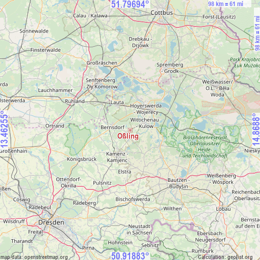
Oßling GPS coordinates[2]
51° 21' 35.964" North, 14° 9' 56.412" East
| Map corner | latitude | longitude |
|---|---|---|
| Upper-left | 51.79694°, | 13.46255° |
| Center: | 51.35999°, | 14.16567° |
| Lower-right: | 50.91883°, | 14.8688° |
| Map W x H: | 97.6×97.6 km | = 60.6×60.6mi |
| max Lat: | 55.01917° ⇑35.8% North |
| Oßling: | 51.35999° |
| min Lat: | ⇓64.2% South 47.40724° |
| min Long | Oßling | max Long |
| 5.92978° | 14.16567° | 14.98853° |
| W 98.5%⇐ | ⇒1.5% E |
Elevation
Elevation of Oßling is 164 m = 538 ft, and this is 85.1 m = 279 ft below average elevation for this country.
| Max E: |
1256 m = 4121 ft | 58.5% |
| Avg. | 249.1 m = 817 ft | |
| Oßling | 164 m = 538 ft | |
Min E: |
-5 m = -16 ft | 41.5% |
See also: Germany elevation on elevation.city.
Geographical zone
Oßling is located in North temperate zone (between Tropic of Cancer and the Arctic Circle). Distance of this North polar circle is 1690.5 km =1050.4 mi to North.| Distance of | km | miles | from Oßling |
|---|---|---|---|
| North Pole | 4296.4 | 2669.7 | to North |
| Arctic Circle | 1690.5 | 1050.4 | to North |
| Tropic Cancer | 3104.8 | 1929.2 | to South |
| Equator | 5710.7 | 3548.5 | to South |


Nearby cities:
15 places around Oßling: (largest is in red/bold)
• Bernsdorf
6.9 km =4.3 mi,  282°
282°
• Crostwitz
14.6 km =9.1 mi,  158°
158°
• Grünewald
12.3 km =7.6 mi,  291°
291°
• Hohenbocka
13.4 km =8.3 mi,  306°
306°
• Horka
12.4 km =7.7 mi,  149°
149°
• Hoyerswerda
9.9 km =6.2 mi,  29°
29°
• Kamenz
11.4 km =7.1 mi,  206°
206°
• Knappenrode
11.8 km =7.3 mi,  65°
65°
• Königswartha
12.6 km =7.8 mi,  116°
116°
• Nebelschütz
10.9 km =6.8 mi,  182°
182°
• Panschwitz-Kuckau
14.2 km =8.8 mi,  170°
170°
• Räckelwitz
13.1 km =8.1 mi, 158°
• Straßgräbchen
7.1 km =4.4 mi,  262°
262°
• Wiednitz
10.1 km =6.3 mi, 286°
• Wittichenau
6.1 km =3.8 mi,  62°
62°
Sources, notices
• [Note1] Compared only with cities in Germany existing in our database
• [Src1] Map data: © OpenStreetMap contributors (CC-BY-SA)
• [Src2] Other city data from geonames.org with taken over terms of usage.
• [Src3] Geographical zone / Annual Mean Temperature by Robert A. Rohde @ Wikipedia
