Tappenbeck geodata
Tappenbeck (Lower Saxony) is a seat of a fourth-order administrative division; located in Germany in Europe/Berlin (GMT+2) time zone. With population of 1,274 people, there are 6381 cities with bigger population in this country. Compared to other cities in Germany, 77.1% of cities are located further ↓South; 63.1% of cities are located further ←West and 74.7% of cities have higher elevation than Tappenbeck. Note1


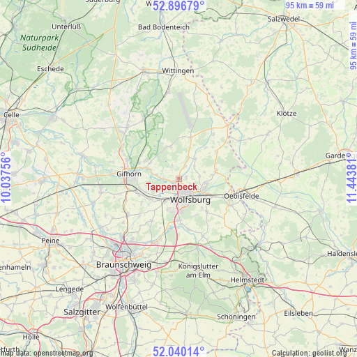
Tappenbeck GPS coordinates[2]
52° 28' 13.98" North, 10° 44' 26.448" East
| Map corner | latitude | longitude |
|---|---|---|
| Upper-left | 52.89679°, | 10.03756° |
| Center: | 52.47055°, | 10.74068° |
| Lower-right: | 52.04014°, | 11.44381° |
| Map W x H: | 95.3×95.2 km | = 59.2×59.2mi |
| max Lat: | 55.01917° ⇑22.9% North |
| Tappenbeck: | 52.47055° |
| min Lat: | ⇓77.1% South 47.40724° |
| min Long | Tappenbeck | max Long |
| 5.92978° | 10.74068° | 14.98853° |
| W 63.1%⇐ | ⇒36.9% E |
Elevation
Elevation of Tappenbeck is 64 m = 210 ft, and this is 185.1 m = 607 ft below average elevation for this country.
| Max E: |
1256 m = 4121 ft | 74.7% |
| Avg. | 249.1 m = 817 ft | |
| Tappenbeck | 64 m = 210 ft | |
Min E: |
-5 m = -16 ft | 25.3% |
See also: Germany elevation on elevation.city.
Geographical zone
Tappenbeck is located in North temperate zone (between Tropic of Cancer and the Arctic Circle). Distance of this North polar circle is 1567 km =973.7 mi to North.| Distance of | km | miles | from Tappenbeck |
|---|---|---|---|
| North Pole | 4172.9 | 2592.9 | to North |
| Arctic Circle | 1567 | 973.7 | to North |
| Tropic Cancer | 3228.3 | 2006 | to South |
| Equator | 5834.2 | 3625.2 | to South |


Nearby cities:
15 places around Tappenbeck: (largest is in red/bold)
• Allerbüttel
8.8 km =5.5 mi,  231°
231°
• Barwedel
6.2 km =3.9 mi,  22°
22°
• Bergfeld
10.8 km =6.7 mi,  40°
40°
• Bokensdorf
3.7 km =2.3 mi,  333°
333°
• Calberlah
9.7 km =6 mi,  235°
235°
• Detmerode
8.9 km =5.5 mi,  178°
178°
• Jembke
3.7 km =2.3 mi,  28°
28°
• Osloß
4.1 km =2.5 mi,  267°
267°
• Rothenfelde
6 km =3.7 mi,  143°
143°
• Rühen
10 km =6.2 mi,  80°
80°
• Sassenburg
8.9 km =5.5 mi,  305°
305°
• Tiddische
6.5 km =4 mi, 38°
• Westhagen
7.4 km =4.6 mi, 180°
• Weyhausen
1.9 km =1.2 mi, 239°
• Wolfsburg
5.8 km =3.6 mi,  151°
151°
Sources, notices
• [Note1] Compared only with cities in Germany existing in our database
• [Src1] Map data: © OpenStreetMap contributors (CC-BY-SA)
• [Src2] Other city data from geonames.org with taken over terms of usage.
• [Src3] Geographical zone / Annual Mean Temperature by Robert A. Rohde @ Wikipedia
