Beetzendorf geodata
Beetzendorf (Saxony-Anhalt) is a seat of a fourth-order administrative division; located in Germany in Europe/Berlin (GMT+2) time zone. With population of 1,942 people, there are 5149 cities with bigger population in this country. Compared to other cities in Germany, 79.7% of cities are located further ↓South; 68.3% of cities are located further ←West and 84.1% of cities have higher elevation than Beetzendorf. Note1
Administrative division(s):
- Level 1: Saxony-Anhalt
- Level 3: Altmarkkreis Salzwedel
- Level 4: Beetzendorf


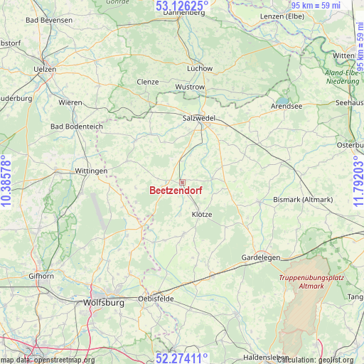
Beetzendorf GPS coordinates[2]
52° 42' 8.136" North, 11° 5' 20.04" East
| Map corner | latitude | longitude |
|---|---|---|
| Upper-left | 53.12625°, | 10.38578° |
| Center: | 52.70226°, | 11.0889° |
| Lower-right: | 52.27411°, | 11.79203° |
| Map W x H: | 94.7×94.7 km | = 58.8×58.8mi |
| max Lat: | 55.01917° ⇑20.3% North |
| Beetzendorf: | 52.70226° |
| min Lat: | ⇓79.7% South 47.40724° |
| min Long | Beetzendorf | max Long |
| 5.92978° | 11.0889° | 14.98853° |
| W 68.3%⇐ | ⇒31.7% E |
Elevation
Elevation of Beetzendorf is 37 m = 121 ft, and this is 212.1 m = 696 ft below average elevation for this country.
| Max E: |
1256 m = 4121 ft | 84.1% |
| Avg. | 249.1 m = 817 ft | |
| Beetzendorf | 37 m = 121 ft | |
Min E: |
-5 m = -16 ft | 15.9% |
See also: Germany elevation on elevation.city.
Geographical zone
Beetzendorf is located in North temperate zone (between Tropic of Cancer and the Arctic Circle). Distance of this North polar circle is 1541.2 km =957.7 mi to North.| Distance of | km | miles | from Beetzendorf |
|---|---|---|---|
| North Pole | 4147.1 | 2576.9 | to North |
| Arctic Circle | 1541.2 | 957.7 | to North |
| Tropic Cancer | 3254 | 2021.9 | to South |
| Equator | 5859.9 | 3641.2 | to South |


Nearby cities:
15 places around Beetzendorf: (largest is in red/bold)
• Apenburg
7.9 km =4.9 mi,  83°
83°
• Bandau
3.7 km =2.3 mi,  156°
156°
• Brome
15.3 km =9.5 mi,  221°
221°
• Immekath
8.5 km =5.3 mi,  183°
183°
• Jübar
12.2 km =7.6 mi,  263°
263°
• Kakerbeck
13.3 km =8.3 mi,  106°
106°
• Klötze
9.8 km =6.1 mi,  148°
148°
• Kuhfelde
9.2 km =5.7 mi,  11°
11°
• Kunrau
15.7 km =9.8 mi,  197°
197°
• Kusey
13.6 km =8.5 mi, 179°
• Osterwohle
15.9 km =9.9 mi,  339°
339°
• Rohrberg
3.3 km =2.1 mi,  280°
280°
• Wallstawe
11.9 km =7.4 mi, 335°
• Wenze
15.6 km =9.7 mi,  168°
168°
• Winterfeld
11.4 km =7.1 mi,  68°
68°
Sources, notices
• [Note1] Compared only with cities in Germany existing in our database
• [Src1] Map data: © OpenStreetMap contributors (CC-BY-SA)
• [Src2] Other city data from geonames.org with taken over terms of usage.
• [Src3] Geographical zone / Annual Mean Temperature by Robert A. Rohde @ Wikipedia
