Bedburg geodata
Bedburg (North Rhine-Westphalia) is a populated place; located in Germany in Europe/Berlin (GMT+2) time zone. With population of 24,937 people, there are 594 cities with bigger population in this country. Compared to other cities in Germany, 58% of cities are located further ↓South; 97.3% of cities are located further →East and 75.3% of cities have higher elevation than Bedburg. Note1
Administrative division(s):
- Level 1: North Rhine-Westphalia
- Level 2: Regierungsbezirk Köln
- Level 3: Rhein-Erft-Kreis
- Level 4: Bedburg


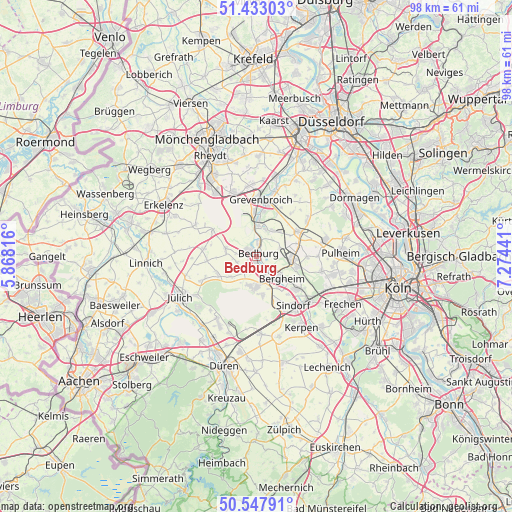
Bedburg GPS coordinates[2]
50° 59' 33.288" North, 6° 34' 16.608" East
| Map corner | latitude | longitude |
|---|---|---|
| Upper-left | 51.43303°, | 5.86816° |
| Center: | 50.99258°, | 6.57128° |
| Lower-right: | 50.54791°, | 7.27441° |
| Map W x H: | 98.4×98.4 km | = 61.1×61.1mi |
| max Lat: | 55.01917° ⇑42% North |
| Bedburg: | 50.99258° |
| min Lat: | ⇓58% South 47.40724° |
| min Long | Bedburg | max Long |
| 5.92978° | 6.57128° | 14.98853° |
| W 2.7%⇐ | ⇒97.3% E |
Elevation
Elevation of Bedburg is 62 m = 203 ft, and this is 187.1 m = 614 ft below average elevation for this country.
| Max E: |
1256 m = 4121 ft | 75.3% |
| Avg. | 249.1 m = 817 ft | |
| Bedburg | 62 m = 203 ft | |
Min E: |
-5 m = -16 ft | 24.7% |
See also: Germany elevation on elevation.city.
Geographical zone
Bedburg is located in North temperate zone (between Tropic of Cancer and the Arctic Circle). Distance of this North polar circle is 1731.3 km =1075.8 mi to North.| Distance of | km | miles | from Bedburg |
|---|---|---|---|
| North Pole | 4337.2 | 2695 | to North |
| Arctic Circle | 1731.3 | 1075.8 | to North |
| Tropic Cancer | 3063.9 | 1903.8 | to South |
| Equator | 5669.8 | 3523 | to South |


Nearby cities:
15 places around Bedburg: (largest is in red/bold)
• Bergheim
6.3 km =3.9 mi,  130°
130°
• Elsdorf
6.1 km =3.8 mi,  181°
181°
• Frechen
18.9 km =11.7 mi,  117°
117°
• Grevenbroich
11 km =6.8 mi,  4°
4°
• Jüchen
12.9 km =8 mi,  337°
337°
• Jülich
16.6 km =10.3 mi,  241°
241°
• Kerpen
16.2 km =10.1 mi,  147°
147°
• Merzenich
18.7 km =11.6 mi,  189°
189°
• Neubrück
16.4 km =10.2 mi,  16°
16°
• Niederzier
14.2 km =8.8 mi,  211°
211°
• Pulheim
16.5 km =10.3 mi,  87°
87°
• Rommerskirchen
9.1 km =5.7 mi,  59°
59°
• Sinnersdorf
17.6 km =10.9 mi,  78°
78°
• Titz
10.4 km =6.5 mi,  278°
278°
• Türnich
19.7 km =12.2 mi,  139°
139°
Sources, notices
• [Note1] Compared only with cities in Germany existing in our database
• [Src1] Map data: © OpenStreetMap contributors (CC-BY-SA)
• [Src2] Other city data from geonames.org with taken over terms of usage.
• [Src3] Geographical zone / Annual Mean Temperature by Robert A. Rohde @ Wikipedia
