Türnich geodata
Türnich (North Rhine-Westphalia) is a populated place; located in Germany in Europe/Berlin (GMT+2) time zone. With population of 3,393 people, there are 3693 cities with bigger population in this country. Compared to other cities in Germany, 55.4% of cities are located further ↓South; 96% of cities are located further →East and 68.8% of cities have higher elevation than Türnich. Note1
Administrative division(s):
- Level 1: North Rhine-Westphalia
- Level 2: Regierungsbezirk Köln
- Level 3: Rhein-Erft-Kreis
- Level 4: Kerpen


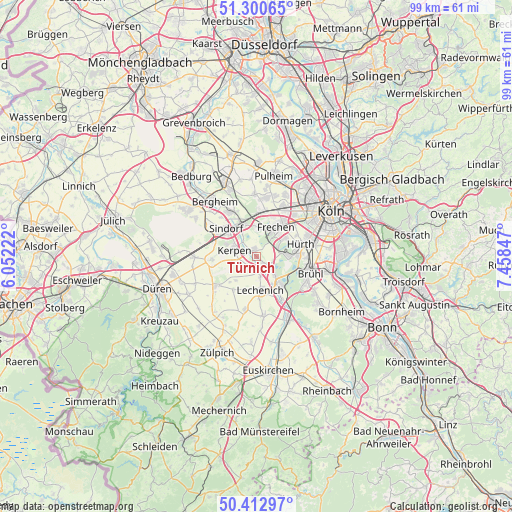
Türnich GPS coordinates[2]
50° 51' 32.112" North, 6° 45' 19.26" East
| Map corner | latitude | longitude |
|---|---|---|
| Upper-left | 51.30065°, | 6.05222° |
| Center: | 50.85892°, | 6.75535° |
| Lower-right: | 50.41297°, | 7.45847° |
| Map W x H: | 98.7×98.7 km | = 61.3×61.3mi |
| max Lat: | 55.01917° ⇑44.6% North |
| Türnich: | 50.85892° |
| min Lat: | ⇓55.4% South 47.40724° |
| min Long | Türnich | max Long |
| 5.92978° | 6.75535° | 14.98853° |
| W 4%⇐ | ⇒96% E |
Elevation
Elevation of Türnich is 98 m = 322 ft, and this is 151.1 m = 496 ft below average elevation for this country.
| Max E: |
1256 m = 4121 ft | 68.8% |
| Avg. | 249.1 m = 817 ft | |
| Türnich | 98 m = 322 ft | |
Min E: |
-5 m = -16 ft | 31.2% |
See also: Germany elevation on elevation.city.
Geographical zone
Türnich is located in North temperate zone (between Tropic of Cancer and the Arctic Circle). Distance of this North polar circle is 1746.2 km =1085 mi to North.| Distance of | km | miles | from Türnich |
|---|---|---|---|
| North Pole | 4352.1 | 2704.3 | to North |
| Arctic Circle | 1746.2 | 1085 | to North |
| Tropic Cancer | 3049.1 | 1894.6 | to South |
| Equator | 5655 | 3513.9 | to South |


Nearby cities:
15 places around Türnich: (largest is in red/bold)
• Bayenthal
16 km =9.9 mi,  68°
68°
• Bergheim
13.5 km =8.4 mi,  323°
323°
• Brühl
11 km =6.8 mi,  107°
107°
• Elsdorf
15.8 km =9.8 mi,  303°
303°
• Erftstadt
5.6 km =3.5 mi,  151°
151°
• Frechen
7.4 km =4.6 mi,  32°
32°
• Hürth
8 km =5 mi,  80°
80°
• Kerpen
4.3 km =2.7 mi,  286°
286°
• Köln
16 km =9.9 mi,  58°
58°
• Mengenich
15.4 km =9.6 mi, 30°
• Neustadt/Süd
15.4 km =9.6 mi, 61°
• Nörvenich
10 km =6.2 mi,  234°
234°
• Pulheim
16.1 km =10 mi,  12°
12°
• Weilerswist
13.4 km =8.3 mi, 151°
• Wesseling
15.8 km =9.8 mi,  102°
102°
Sources, notices
• [Note1] Compared only with cities in Germany existing in our database
• [Src1] Map data: © OpenStreetMap contributors (CC-BY-SA)
• [Src2] Other city data from geonames.org with taken over terms of usage.
• [Src3] Geographical zone / Annual Mean Temperature by Robert A. Rohde @ Wikipedia
