Bergheim geodata
Bergheim (North Rhine-Westphalia) is a seat of a third-order administrative division; located in Germany in Europe/Berlin (GMT+2) time zone. With population of 63,558 people, there are 165 cities with bigger population in this country. Compared to other cities in Germany, 57.3% of cities are located further ↓South; 96.7% of cities are located further →East and 74.1% of cities have higher elevation than Bergheim. Note1
Administrative division(s):
- Level 1: North Rhine-Westphalia
- Level 2: Regierungsbezirk Köln
- Level 3: Rhein-Erft-Kreis
- Level 4: Bergheim


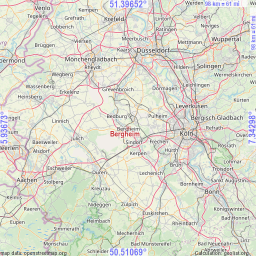
Bergheim GPS coordinates[2]
50° 57' 20.592" North, 6° 38' 23.496" East
| Map corner | latitude | longitude |
|---|---|---|
| Upper-left | 51.39652°, | 5.93673° |
| Center: | 50.95572°, | 6.63986° |
| Lower-right: | 50.51069°, | 7.34298° |
| Map W x H: | 98.5×98.5 km | = 61.2×61.2mi |
| max Lat: | 55.01917° ⇑42.7% North |
| Bergheim: | 50.95572° |
| min Lat: | ⇓57.3% South 47.40724° |
| min Long | Bergheim | max Long |
| 5.92978° | 6.63986° | 14.98853° |
| W 3.3%⇐ | ⇒96.7% E |
Elevation
Elevation of Bergheim is 67 m = 220 ft, and this is 182.1 m = 597 ft below average elevation for this country.
| Max E: |
1256 m = 4121 ft | 74.1% |
| Avg. | 249.1 m = 817 ft | |
| Bergheim | 67 m = 220 ft | |
Min E: |
-5 m = -16 ft | 25.9% |
See also: Bergheim elevation on elevation.city.
Geographical zone
Bergheim is located in North temperate zone (between Tropic of Cancer and the Arctic Circle). Distance of this North polar circle is 1735.4 km =1078.3 mi to North.| Distance of | km | miles | from Bergheim |
|---|---|---|---|
| North Pole | 4341.3 | 2697.6 | to North |
| Arctic Circle | 1735.4 | 1078.3 | to North |
| Tropic Cancer | 3059.8 | 1901.3 | to South |
| Equator | 5665.7 | 3520.5 | to South |


Nearby cities:
15 places around Bergheim: (largest is in red/bold)
• Bedburg
6.3 km =3.9 mi,  310°
310°
• Elsdorf
5.4 km =3.4 mi,  247°
247°
• Frechen
12.9 km =8 mi,  110°
110°
• Grevenbroich
15.6 km =9.7 mi,  345°
345°
• Hürth
18.5 km =11.5 mi,  120°
120°
• Kerpen
10.3 km =6.4 mi,  157°
157°
• Mengenich
16.1 km =10 mi,  80°
80°
• Merzenich
16.4 km =10.2 mi,  209°
209°
• Niederzier
14.6 km =9.1 mi,  236°
236°
• Nörvenich
16.6 km =10.3 mi,  180°
180°
• Pulheim
12.6 km =7.8 mi,  67°
67°
• Rommerskirchen
9.1 km =5.7 mi,  19°
19°
• Sinnersdorf
14.6 km =9.1 mi,  58°
58°
• Titz
16.1 km =10 mi,  290°
290°
• Türnich
13.5 km =8.4 mi,  143°
143°
Sources, notices
• [Note1] Compared only with cities in Germany existing in our database
• [Src1] Map data: © OpenStreetMap contributors (CC-BY-SA)
• [Src2] Other city data from geonames.org with taken over terms of usage.
• [Src3] Geographical zone / Annual Mean Temperature by Robert A. Rohde @ Wikipedia
