Balingen geodata
Balingen (Baden-Württemberg) is a seat of a third-order administrative division; located in Germany in Europe/Berlin (GMT+2) time zone. With population of 34,414 people, there are 390 cities with bigger population in this country. Compared to other cities in Germany, 91.6% of cities are located further ↑North; 67.2% of cities are located further →East and 89.8% of cities have lower elevation than Balingen. Note1
Administrative division(s):
- Level 1: Baden-Württemberg
- Level 2: Tübingen Region
- Level 3: Zollernalbkreis
- Level 4: Balingen


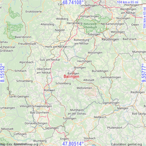
Balingen GPS coordinates[2]
48° 16' 30.9" North, 8° 51' 16.704" East
| Map corner | latitude | longitude |
|---|---|---|
| Upper-left | 48.74108°, | 8.15152° |
| Center: | 48.27525°, | 8.85464° |
| Lower-right: | 47.80514°, | 9.55777° |
| Map W x H: | 104.1×104.1 km | = 64.7×64.7mi |
| max Lat: | 55.01917° ⇑91.6% North |
| Balingen: | 48.27525° |
| min Lat: | ⇓8.4% South 47.40724° |
| min Long | Balingen | max Long |
| 5.92978° | 8.85464° | 14.98853° |
| W 32.8%⇐ | ⇒67.2% E |
Elevation
Elevation of Balingen is 512 m = 1680 ft, and this is 262.9 m = 863 ft above average elevation for this country.
| Max E: |
1256 m = 4121 ft | 10.2% |
| Balingen | 512 m 1680 ft | |
| Avg. | 249.1 m = 817 ft | |
Min E: |
-5 m = -16 ft | 89.8% |
See also: Germany elevation on elevation.city.
Geographical zone
Balingen is located in North temperate zone (between Tropic of Cancer and the Arctic Circle). Distance of this North polar circle is 2033.5 km =1263.6 mi to North.| Distance of | km | miles | from Balingen |
|---|---|---|---|
| North Pole | 4639.4 | 2882.8 | to North |
| Arctic Circle | 2033.5 | 1263.6 | to North |
| Tropic Cancer | 2761.8 | 1716.1 | to South |
| Equator | 5367.7 | 3335.3 | to South |


Nearby cities:
15 places around Balingen: (largest is in red/bold)
• Bisingen
6 km =3.7 mi,  50°
50°
• Dautmergen
9.2 km =5.7 mi,  246°
246°
• Dormettingen
7.4 km =4.6 mi,  234°
234°
• Dotternhausen
7 km =4.3 mi,  221°
221°
• Geislingen
3.4 km =2.1 mi,  293°
293°
• Grosselfingen
6.8 km =4.2 mi,  20°
20°
• Haigerloch
10.8 km =6.7 mi,  339°
339°
• Hausen am Tann
8.7 km =5.4 mi,  189°
189°
• Hechingen
11.7 km =7.3 mi,  43°
43°
• Rangendingen
12.1 km =7.5 mi,  12°
12°
• Ratshausen
10.1 km =6.3 mi,  205°
205°
• Rosenfeld
9.8 km =6.1 mi,  277°
277°
• Schömberg
10.1 km =6.3 mi, 224°
• Weilen unter den Rinnen
11.6 km =7.2 mi, 214°
• Zimmern unter der Burg
11.7 km =7.3 mi,  238°
238°
Sources, notices
• [Note1] Compared only with cities in Germany existing in our database
• [Src1] Map data: © OpenStreetMap contributors (CC-BY-SA)
• [Src2] Other city data from geonames.org with taken over terms of usage.
• [Src3] Geographical zone / Annual Mean Temperature by Robert A. Rohde @ Wikipedia
