Haigerloch geodata
Haigerloch (Baden-Württemberg) is a populated place; located in Germany in Europe/Berlin (GMT+2) time zone. With population of 10,828 people, there are 1525 cities with bigger population in this country. Compared to other cities in Germany, 90.6% of cities are located further ↑North; 67.9% of cities are located further →East and 81.4% of cities have lower elevation than Haigerloch. Note1
Administrative division(s):
- Level 1: Baden-Württemberg
- Level 2: Tübingen Region
- Level 3: Zollernalbkreis
- Level 4: Haigerloch


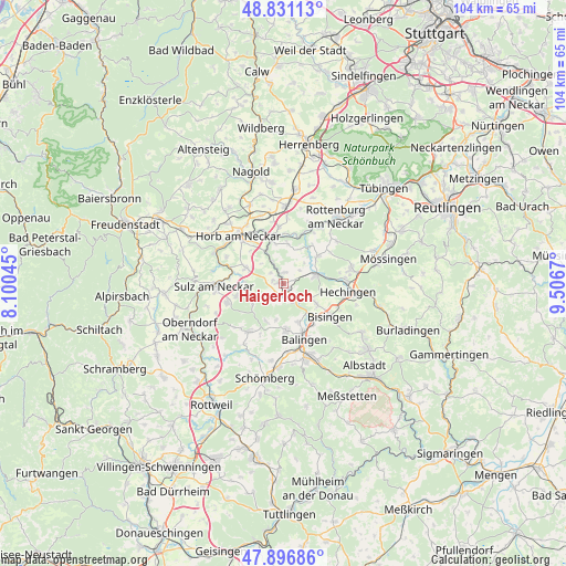
Haigerloch GPS coordinates[2]
48° 21' 58.104" North, 8° 48' 12.852" East
| Map corner | latitude | longitude |
|---|---|---|
| Upper-left | 48.83113°, | 8.10045° |
| Center: | 48.36614°, | 8.80357° |
| Lower-right: | 47.89686°, | 9.5067° |
| Map W x H: | 103.9×103.9 km | = 64.6×64.6mi |
| max Lat: | 55.01917° ⇑90.6% North |
| Haigerloch: | 48.36614° |
| min Lat: | ⇓9.4% South 47.40724° |
| min Long | Haigerloch | max Long |
| 5.92978° | 8.80357° | 14.98853° |
| W 32.1%⇐ | ⇒67.9% E |
Elevation
Elevation of Haigerloch is 443 m = 1453 ft, and this is 193.9 m = 636 ft above average elevation for this country.
| Max E: |
1256 m = 4121 ft | 18.6% |
| Haigerloch | 443 m 1453 ft | |
| Avg. | 249.1 m = 817 ft | |
Min E: |
-5 m = -16 ft | 81.4% |
See also: Germany elevation on elevation.city.
Geographical zone
Haigerloch is located in North temperate zone (between Tropic of Cancer and the Arctic Circle). Distance of this North polar circle is 2023.4 km =1257.3 mi to North.| Distance of | km | miles | from Haigerloch |
|---|---|---|---|
| North Pole | 4629.3 | 2876.5 | to North |
| Arctic Circle | 2023.4 | 1257.3 | to North |
| Tropic Cancer | 2771.9 | 1722.4 | to South |
| Equator | 5377.8 | 3341.6 | to South |


Nearby cities:
15 places around Haigerloch: (largest is in red/bold)
• Balingen
10.8 km =6.7 mi,  159°
159°
• Bisingen
10.5 km =6.5 mi,  126°
126°
• Bodelshausen
13.1 km =8.1 mi,  78°
78°
• Dormettingen
14.5 km =9 mi,  188°
188°
• Empfingen
7.5 km =4.7 mi,  293°
293°
• Geislingen
8.7 km =5.4 mi,  175°
175°
• Grosselfingen
7.2 km =4.5 mi,  121°
121°
• Hechingen
11.9 km =7.4 mi,  97°
97°
• Hirrlingen
8.1 km =5 mi,  50°
50°
• Horb am Neckar
12 km =7.5 mi,  316°
316°
• Mühlheim am Bach
8 km =5 mi,  280°
280°
• Rangendingen
6.6 km =4.1 mi,  74°
74°
• Rosenfeld
10.7 km =6.6 mi,  213°
213°
• Sulz am Neckar
12.6 km =7.8 mi,  268°
268°
• Vöhringen
10.9 km =6.8 mi,  251°
251°
Sources, notices
• [Note1] Compared only with cities in Germany existing in our database
• [Src1] Map data: © OpenStreetMap contributors (CC-BY-SA)
• [Src2] Other city data from geonames.org with taken over terms of usage.
• [Src3] Geographical zone / Annual Mean Temperature by Robert A. Rohde @ Wikipedia
