Nordhalben geodata
Nordhalben (Bavaria) is a populated place; located in Germany in Europe/Berlin (GMT+2) time zone. With population of 2,077 people, there are 4961 cities with bigger population in this country. Compared to other cities in Germany, 55.1% of cities are located further ↑North; 74.4% of cities are located further ←West and 95.2% of cities have lower elevation than Nordhalben. Note1
Administrative division(s):
- Level 1: Bavaria
- Level 2: Upper Franconia
- Level 3: Landkreis Kronach
- Level 4: Nordhalben, Markt


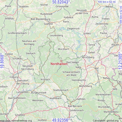
Nordhalben GPS coordinates[2]
50° 22' 26.796" North, 11° 30' 35.712" East
| Map corner | latitude | longitude |
|---|---|---|
| Upper-left | 50.82043°, | 10.8068° |
| Center: | 50.37411°, | 11.50992° |
| Lower-right: | 49.92356°, | 12.21305° |
| Map W x H: | 99.7×99.7 km | = 62×62mi |
| max Lat: | 55.01917° ⇑55.1% North |
| Nordhalben: | 50.37411° |
| min Lat: | ⇓44.9% South 47.40724° |
| min Long | Nordhalben | max Long |
| 5.92978° | 11.50992° | 14.98853° |
| W 74.4%⇐ | ⇒25.6% E |
Elevation
Elevation of Nordhalben is 603 m = 1978 ft, and this is 353.9 m = 1161 ft above average elevation for this country.
| Max E: |
1256 m = 4121 ft | 4.8% |
| Nordhalben | 603 m 1978 ft | |
| Avg. | 249.1 m = 817 ft | |
Min E: |
-5 m = -16 ft | 95.2% |
See also: Germany elevation on elevation.city.
Geographical zone
Nordhalben is located in North temperate zone (between Tropic of Cancer and the Arctic Circle). Distance of this North polar circle is 1800.1 km =1118.5 mi to North.| Distance of | km | miles | from Nordhalben |
|---|---|---|---|
| North Pole | 4406 | 2737.8 | to North |
| Arctic Circle | 1800.1 | 1118.5 | to North |
| Tropic Cancer | 2995.2 | 1861.1 | to South |
| Equator | 5601.1 | 3480.4 | to South |


Nearby cities:
15 places around Nordhalben: (largest is in red/bold)
• Bad Lobenstein
12.6 km =7.8 mi,  46°
46°
• Bad Steben
9.6 km =6 mi,  95°
95°
• Blankenstein
13.8 km =8.6 mi,  76°
76°
• Geroldsgrün
7.8 km =4.8 mi,  125°
125°
• Harra
13.2 km =8.2 mi,  68°
68°
• Lichtenberg
11.8 km =7.3 mi,  85°
85°
• Pressig
14.4 km =8.9 mi,  260°
260°
• Reichenbach
8.8 km =5.5 mi,  309°
309°
• Schlegel
8.1 km =5 mi, 69°
• Steinwiesen
9.5 km =5.9 mi,  200°
200°
• Teuschnitz
9.4 km =5.8 mi,  286°
286°
• Tschirn
5.1 km =3.2 mi,  304°
304°
• Wallenfels
12.1 km =7.5 mi,  193°
193°
• Wilhelmsthal
12 km =7.5 mi,  234°
234°
• Wurzbach
10.1 km =6.3 mi,  11°
11°
Sources, notices
• [Note1] Compared only with cities in Germany existing in our database
• [Src1] Map data: © OpenStreetMap contributors (CC-BY-SA)
• [Src2] Other city data from geonames.org with taken over terms of usage.
• [Src3] Geographical zone / Annual Mean Temperature by Robert A. Rohde @ Wikipedia
