Bad Schwalbach geodata
Bad Schwalbach (Hesse) is a seat of a third-order administrative division; located in Germany in Europe/Berlin (GMT+2) time zone. With population of 11,112 people, there are 1486 cities with bigger population in this country. Compared to other cities in Germany, 60.3% of cities are located further ↑North; 75.9% of cities are located further →East and 65.4% of cities have lower elevation than Bad Schwalbach. Note1
Administrative division(s):
- Level 1: Hesse
- Level 2: Regierungsbezirk Darmstadt
- Level 3: Rheingau-Taunus-Kreis
- Level 4: Bad Schwalbach, Kreisstadt


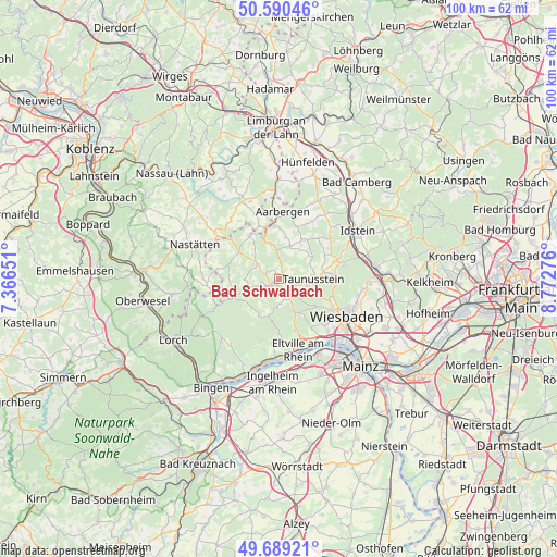
Bad Schwalbach GPS coordinates[2]
50° 8' 31.056" North, 8° 4' 10.704" East
| Map corner | latitude | longitude |
|---|---|---|
| Upper-left | 50.59046°, | 7.36651° |
| Center: | 50.14196°, | 8.06964° |
| Lower-right: | 49.68921°, | 8.77276° |
| Map W x H: | 100.2×100.2 km | = 62.3×62.3mi |
| max Lat: | 55.01917° ⇑60.3% North |
| Bad Schwalbach: | 50.14196° |
| min Lat: | ⇓39.7% South 47.40724° |
| min Long | Bad Schwalbach | max Long |
| 5.92978° | 8.06964° | 14.98853° |
| W 24.1%⇐ | ⇒75.9% E |
Elevation
Elevation of Bad Schwalbach is 324 m = 1063 ft, and this is 74.9 m = 246 ft above average elevation for this country.
| Max E: |
1256 m = 4121 ft | 34.6% |
| Bad Schwalbach | 324 m 1063 ft | |
| Avg. | 249.1 m = 817 ft | |
Min E: |
-5 m = -16 ft | 65.4% |
See also: Germany elevation on elevation.city.
Geographical zone
Bad Schwalbach is located in North temperate zone (between Tropic of Cancer and the Arctic Circle). Distance of this North polar circle is 1825.9 km =1134.6 mi to North.| Distance of | km | miles | from Bad Schwalbach |
|---|---|---|---|
| North Pole | 4431.8 | 2753.8 | to North |
| Arctic Circle | 1825.9 | 1134.6 | to North |
| Tropic Cancer | 2969.3 | 1845 | to South |
| Equator | 5575.3 | 3464.3 | to South |


Nearby cities:
15 places around Bad Schwalbach: (largest is in red/bold)
• Berghausen
13.7 km =8.5 mi,  341°
341°
• Berndroth
12.8 km =8 mi,  325°
325°
• Burg Hohenstein
5.6 km =3.5 mi,  351°
351°
• Dörsdorf
12.3 km =7.6 mi, 339°
• Eisighofen
10.8 km =6.7 mi, 339°
• Eltville
13.1 km =8.1 mi,  164°
164°
• Kiedrich
11.4 km =7.1 mi,  174°
174°
• Reckenroth
10.3 km =6.4 mi, 341°
• Rettert
13.6 km =8.5 mi,  316°
316°
• Schlangenbad
5.9 km =3.7 mi, 156°
• Strüth
13.3 km =8.3 mi,  265°
265°
• Taunusstein
5.9 km =3.7 mi,  81°
81°
• Walluf
12.9 km =8 mi,  151°
151°
• Weidenbach
13.3 km =8.3 mi, 273°
• Welterod
13.3 km =8.3 mi, 265°
Sources, notices
• [Note1] Compared only with cities in Germany existing in our database
• [Src1] Map data: © OpenStreetMap contributors (CC-BY-SA)
• [Src2] Other city data from geonames.org with taken over terms of usage.
• [Src3] Geographical zone / Annual Mean Temperature by Robert A. Rohde @ Wikipedia
