Schlangenbad geodata
Schlangenbad (Hesse) is a seat of a fourth-order administrative division; located in Germany in Europe/Berlin (GMT+2) time zone. With population of 6,265 people, there are 2378 cities with bigger population in this country. Compared to other cities in Germany, 61.5% of cities are located further ↑North; 75.4% of cities are located further →East and 59.5% of cities have lower elevation than Schlangenbad. Note1
Administrative division(s):
- Level 1: Hesse
- Level 2: Regierungsbezirk Darmstadt
- Level 3: Rheingau-Taunus-Kreis
- Level 4: Schlangenbad


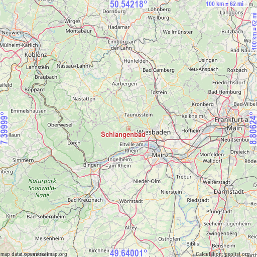
Schlangenbad GPS coordinates[2]
50° 5' 35.592" North, 8° 6' 11.232" East
| Map corner | latitude | longitude |
|---|---|---|
| Upper-left | 50.54218°, | 7.39999° |
| Center: | 50.09322°, | 8.10312° |
| Lower-right: | 49.64001°, | 8.80624° |
| Map W x H: | 100.3×100.3 km | = 62.3×62.3mi |
| max Lat: | 55.01917° ⇑61.5% North |
| Schlangenbad: | 50.09322° |
| min Lat: | ⇓38.5% South 47.40724° |
| min Long | Schlangenbad | max Long |
| 5.92978° | 8.10312° | 14.98853° |
| W 24.6%⇐ | ⇒75.4% E |
Elevation
Elevation of Schlangenbad is 287 m = 942 ft, and this is 37.9 m = 124 ft above average elevation for this country.
| Max E: |
1256 m = 4121 ft | 40.5% |
| Schlangenbad | 287 m 942 ft | |
| Avg. | 249.1 m = 817 ft | |
Min E: |
-5 m = -16 ft | 59.5% |
See also: Germany elevation on elevation.city.
Geographical zone
Schlangenbad is located in North temperate zone (between Tropic of Cancer and the Arctic Circle). Distance of this North polar circle is 1831.3 km =1137.9 mi to North.| Distance of | km | miles | from Schlangenbad |
|---|---|---|---|
| North Pole | 4437.2 | 2757.1 | to North |
| Arctic Circle | 1831.3 | 1137.9 | to North |
| Tropic Cancer | 2963.9 | 1841.7 | to South |
| Equator | 5569.8 | 3460.9 | to South |


Nearby cities:
15 places around Schlangenbad: (largest is in red/bold)
• Bad Schwalbach
5.9 km =3.7 mi,  336°
336°
• Budenheim
9.6 km =6 mi,  151°
151°
• Burg Hohenstein
11.4 km =7.1 mi, 343°
• Eltville
7.3 km =4.5 mi,  171°
171°
• Geisenheim
15.4 km =9.6 mi,  218°
218°
• Ingelheim am Rhein
14 km =8.7 mi,  193°
193°
• Kiedrich
6.1 km =3.8 mi, 192°
• Nieder-Ingelheim
13 km =8.1 mi, 189°
• Reckenroth
16.2 km =10.1 mi, 339°
• Strüth
16.3 km =10.1 mi,  285°
285°
• Taunusstein
7.2 km =4.5 mi,  28°
28°
• Wackernheim
13.2 km =8.2 mi,  175°
175°
• Walluf
7 km =4.3 mi, 147°
• Welterod
16.3 km =10.1 mi, 285°
• Wiesbaden
10.5 km =6.5 mi,  96°
96°
Sources, notices
• [Note1] Compared only with cities in Germany existing in our database
• [Src1] Map data: © OpenStreetMap contributors (CC-BY-SA)
• [Src2] Other city data from geonames.org with taken over terms of usage.
• [Src3] Geographical zone / Annual Mean Temperature by Robert A. Rohde @ Wikipedia
