Walluf geodata
Walluf (Hesse) is a seat of a fourth-order administrative division; located in Germany in Europe/Berlin (GMT+2) time zone. With population of 5,698 people, there are 2566 cities with bigger population in this country. Compared to other cities in Germany, 62.6% of cities are located further ↑North; 74.7% of cities are located further →East and 65.4% of cities have higher elevation than Walluf. Note1
Administrative division(s):
- Level 1: Hesse
- Level 2: Regierungsbezirk Darmstadt
- Level 3: Rheingau-Taunus-Kreis
- Level 4: Walluf


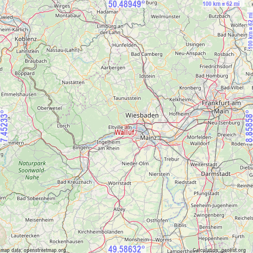
Walluf GPS coordinates[2]
50° 2' 24.108" North, 8° 9' 19.62" East
| Map corner | latitude | longitude |
|---|---|---|
| Upper-left | 50.48949°, | 7.45233° |
| Center: | 50.04003°, | 8.15545° |
| Lower-right: | 49.58632°, | 8.85858° |
| Map W x H: | 100.4×100.4 km | = 62.4×62.4mi |
| max Lat: | 55.01917° ⇑62.6% North |
| Walluf: | 50.04003° |
| min Lat: | ⇓37.4% South 47.40724° |
| min Long | Walluf | max Long |
| 5.92978° | 8.15545° | 14.98853° |
| W 25.3%⇐ | ⇒74.7% E |
Elevation
Elevation of Walluf is 118 m = 387 ft, and this is 131.1 m = 430 ft below average elevation for this country.
| Max E: |
1256 m = 4121 ft | 65.4% |
| Avg. | 249.1 m = 817 ft | |
| Walluf | 118 m = 387 ft | |
Min E: |
-5 m = -16 ft | 34.6% |
See also: Germany elevation on elevation.city.
Geographical zone
Walluf is located in North temperate zone (between Tropic of Cancer and the Arctic Circle). Distance of this North polar circle is 1837.2 km =1141.6 mi to North.| Distance of | km | miles | from Walluf |
|---|---|---|---|
| North Pole | 4443.1 | 2760.8 | to North |
| Arctic Circle | 1837.2 | 1141.6 | to North |
| Tropic Cancer | 2958 | 1838 | to South |
| Equator | 5563.9 | 3457.2 | to South |


Nearby cities:
15 places around Walluf: (largest is in red/bold)
• Bad Schwalbach
12.9 km =8 mi,  331°
331°
• Budenheim
2.7 km =1.7 mi,  162°
162°
• Eltville
3 km =1.9 mi,  244°
244°
• Essenheim
12.2 km =7.6 mi,  179°
179°
• Ingelheim am Rhein
10.3 km =6.4 mi,  221°
221°
• Kiedrich
5 km =3.1 mi,  269°
269°
• Klein-Winternheim
12 km =7.5 mi, 160°
• Mainz
10.8 km =6.7 mi,  125°
125°
• Nieder-Ingelheim
9.1 km =5.7 mi, 220°
• Ober-Olm
11.7 km =7.3 mi,  168°
168°
• Schlangenbad
7 km =4.3 mi, 327°
• Schwabenheim
13.1 km =8.1 mi,  199°
199°
• Taunusstein
12.2 km =7.6 mi,  358°
358°
• Wackernheim
7.8 km =4.8 mi, 200°
• Wiesbaden
8.2 km =5.1 mi,  54°
54°
Sources, notices
• [Note1] Compared only with cities in Germany existing in our database
• [Src1] Map data: © OpenStreetMap contributors (CC-BY-SA)
• [Src2] Other city data from geonames.org with taken over terms of usage.
• [Src3] Geographical zone / Annual Mean Temperature by Robert A. Rohde @ Wikipedia
