Eltville geodata
Eltville (Hesse) is a populated place; located in Germany in Europe/Berlin (GMT+2) time zone. With population of 16,845 people, there are 940 cities with bigger population in this country. Compared to other cities in Germany, 63.1% of cities are located further ↑North; 75.1% of cities are located further →East and 68.7% of cities have higher elevation than Eltville. Note1
Administrative division(s):
- Level 1: Hesse
- Level 2: Regierungsbezirk Darmstadt
- Level 3: Rheingau-Taunus-Kreis
- Level 4: Eltville am Rhein


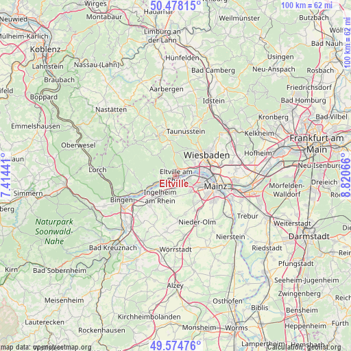
Eltville GPS coordinates[2]
50° 1' 42.888" North, 8° 7' 3.144" East
| Map corner | latitude | longitude |
|---|---|---|
| Upper-left | 50.47815°, | 7.41441° |
| Center: | 50.02858°, | 8.11754° |
| Lower-right: | 49.57476°, | 8.82066° |
| Map W x H: | 100.4×100.4 km | = 62.4×62.4mi |
| max Lat: | 55.01917° ⇑63.1% North |
| Eltville: | 50.02858° |
| min Lat: | ⇓36.9% South 47.40724° |
| min Long | Eltville | max Long |
| 5.92978° | 8.11754° | 14.98853° |
| W 24.9%⇐ | ⇒75.1% E |
Elevation
Elevation of Eltville is 99 m = 325 ft, and this is 150.1 m = 492 ft below average elevation for this country.
| Max E: |
1256 m = 4121 ft | 68.7% |
| Avg. | 249.1 m = 817 ft | |
| Eltville | 99 m = 325 ft | |
Min E: |
-5 m = -16 ft | 31.3% |
See also: Germany elevation on elevation.city.
Geographical zone
Eltville is located in North temperate zone (between Tropic of Cancer and the Arctic Circle). Distance of this North polar circle is 1838.5 km =1142.4 mi to North.| Distance of | km | miles | from Eltville |
|---|---|---|---|
| North Pole | 4444.4 | 2761.6 | to North |
| Arctic Circle | 1838.5 | 1142.4 | to North |
| Tropic Cancer | 2956.7 | 1837.2 | to South |
| Equator | 5562.7 | 3456.5 | to South |


Nearby cities:
15 places around Eltville: (largest is in red/bold)
• Bubenheim
12.2 km =7.6 mi,  192°
192°
• Budenheim
3.8 km =2.4 mi,  110°
110°
• Essenheim
11.2 km =7 mi,  165°
165°
• Gau-Algesheim
10.8 km =6.7 mi,  222°
222°
• Geisenheim
11.7 km =7.3 mi,  245°
245°
• Ingelheim am Rhein
7.7 km =4.8 mi,  213°
213°
• Kiedrich
2.6 km =1.6 mi,  298°
298°
• Klein-Winternheim
12.1 km =7.5 mi,  146°
146°
• Nieder-Ingelheim
6.5 km =4 mi, 209°
• Ober-Olm
11.4 km =7.1 mi, 153°
• Schlangenbad
7.3 km =4.5 mi,  351°
351°
• Schwabenheim
11.2 km =7 mi, 188°
• Wackernheim
6 km =3.7 mi,  180°
180°
• Walluf
3 km =1.9 mi,  64°
64°
• Wiesbaden
11.2 km =7 mi, 57°
Sources, notices
• [Note1] Compared only with cities in Germany existing in our database
• [Src1] Map data: © OpenStreetMap contributors (CC-BY-SA)
• [Src2] Other city data from geonames.org with taken over terms of usage.
• [Src3] Geographical zone / Annual Mean Temperature by Robert A. Rohde @ Wikipedia
