Taunusstein geodata
Taunusstein (Hesse) is a populated place; located in Germany in Europe/Berlin (GMT+2) time zone. With population of 29,501 people, there are 476 cities with bigger population in this country. Compared to other cities in Germany, 60.2% of cities are located further ↑North; 74.7% of cities are located further →East and 72.8% of cities have lower elevation than Taunusstein. Note1
Administrative division(s):
- Level 1: Hesse
- Level 2: Regierungsbezirk Darmstadt
- Level 3: Rheingau-Taunus-Kreis
- Level 4: Taunusstein


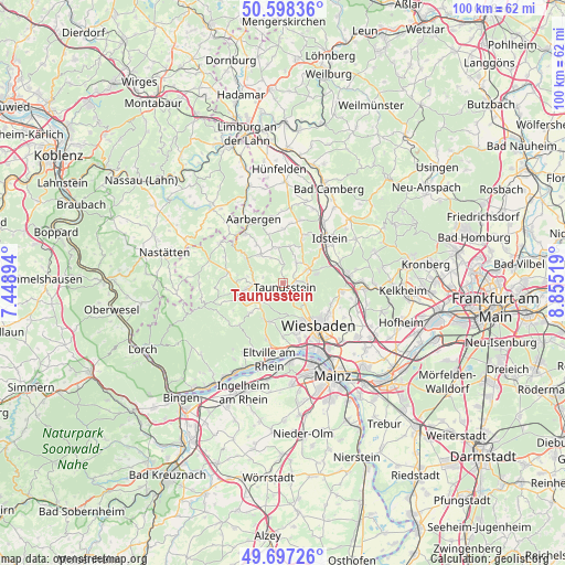
Taunusstein GPS coordinates[2]
50° 8' 59.748" North, 8° 9' 7.416" East
| Map corner | latitude | longitude |
|---|---|---|
| Upper-left | 50.59836°, | 7.44894° |
| Center: | 50.14993°, | 8.15206° |
| Lower-right: | 49.69726°, | 8.85519° |
| Map W x H: | 100.2×100.2 km | = 62.3×62.3mi |
| max Lat: | 55.01917° ⇑60.2% North |
| Taunusstein: | 50.14993° |
| min Lat: | ⇓39.8% South 47.40724° |
| min Long | Taunusstein | max Long |
| 5.92978° | 8.15206° | 14.98853° |
| W 25.3%⇐ | ⇒74.7% E |
Elevation
Elevation of Taunusstein is 381 m = 1250 ft, and this is 131.9 m = 433 ft above average elevation for this country.
| Max E: |
1256 m = 4121 ft | 27.2% |
| Taunusstein | 381 m 1250 ft | |
| Avg. | 249.1 m = 817 ft | |
Min E: |
-5 m = -16 ft | 72.8% |
See also: Germany elevation on elevation.city.
Geographical zone
Taunusstein is located in North temperate zone (between Tropic of Cancer and the Arctic Circle). Distance of this North polar circle is 1825 km =1134 mi to North.| Distance of | km | miles | from Taunusstein |
|---|---|---|---|
| North Pole | 4430.9 | 2753.2 | to North |
| Arctic Circle | 1825 | 1134 | to North |
| Tropic Cancer | 2970.2 | 1845.6 | to South |
| Equator | 5576.1 | 3464.8 | to South |


Nearby cities:
15 places around Taunusstein: (largest is in red/bold)
• Bad Schwalbach
5.9 km =3.7 mi,  261°
261°
• Budenheim
14.9 km =9.3 mi,  175°
175°
• Burg Hohenstein
8.2 km =5.1 mi,  304°
304°
• Burgschwalbach
15.6 km =9.7 mi,  341°
341°
• Dörsdorf
14.7 km =9.1 mi,  316°
316°
• Eisighofen
13.4 km =8.3 mi,  313°
313°
• Eltville
13.7 km =8.5 mi,  190°
190°
• Idstein
11.1 km =6.9 mi,  47°
47°
• Kiedrich
13.2 km =8.2 mi,  201°
201°
• Niedernhausen
11.6 km =7.2 mi,  82°
82°
• Reckenroth
12.8 km =8 mi, 314°
• Schiesheim
15.7 km =9.8 mi,  333°
333°
• Schlangenbad
7.2 km =4.5 mi,  208°
208°
• Walluf
12.2 km =7.6 mi, 178°
• Wiesbaden
10.2 km =6.3 mi,  137°
137°
Sources, notices
• [Note1] Compared only with cities in Germany existing in our database
• [Src1] Map data: © OpenStreetMap contributors (CC-BY-SA)
• [Src2] Other city data from geonames.org with taken over terms of usage.
• [Src3] Geographical zone / Annual Mean Temperature by Robert A. Rohde @ Wikipedia
