Bad Salzuflen geodata
Bad Salzuflen (North Rhine-Westphalia) is a populated place; located in Germany in Europe/Berlin (GMT+2) time zone. With population of 54,899 people, there are 194 cities with bigger population in this country. Compared to other cities in Germany, 72.9% of cities are located further ↓South; 68.6% of cities are located further →East and 71.3% of cities have higher elevation than Bad Salzuflen. Note1
Administrative division(s):
- Level 1: North Rhine-Westphalia
- Level 2: Regierungsbezirk Detmold
- Level 3: Kreis Lippe
- Level 4: Bad Salzuflen


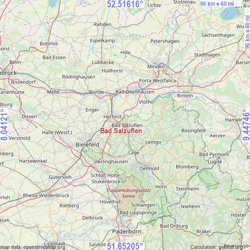
Bad Salzuflen GPS coordinates[2]
52° 5' 10.32" North, 8° 44' 39.624" East
| Map corner | latitude | longitude |
|---|---|---|
| Upper-left | 52.51616°, | 8.04121° |
| Center: | 52.0862°, | 8.74434° |
| Lower-right: | 51.65205°, | 9.44746° |
| Map W x H: | 96.1×96.1 km | = 59.7×59.7mi |
| max Lat: | 55.01917° ⇑27.1% North |
| Bad Salzuflen: | 52.0862° |
| min Lat: | ⇓72.9% South 47.40724° |
| min Long | Bad Salzuflen | max Long |
| 5.92978° | 8.74434° | 14.98853° |
| W 31.4%⇐ | ⇒68.6% E |
Elevation
Elevation of Bad Salzuflen is 82 m = 269 ft, and this is 167.1 m = 548 ft below average elevation for this country.
| Max E: |
1256 m = 4121 ft | 71.3% |
| Avg. | 249.1 m = 817 ft | |
| Bad Salzuflen | 82 m = 269 ft | |
Min E: |
-5 m = -16 ft | 28.7% |
See also: Bad Salzuflen elevation on elevation.city.
Geographical zone
Bad Salzuflen is located in North temperate zone (between Tropic of Cancer and the Arctic Circle). Distance of this North polar circle is 1609.7 km =1000.2 mi to North.| Distance of | km | miles | from Bad Salzuflen |
|---|---|---|---|
| North Pole | 4215.6 | 2619.5 | to North |
| Arctic Circle | 1609.7 | 1000.2 | to North |
| Tropic Cancer | 3185.5 | 1979.4 | to South |
| Equator | 5791.4 | 3598.6 | to South |


Nearby cities:
15 places around Bad Salzuflen: (largest is in red/bold)
• Bad Oeynhausen
14 km =8.7 mi,  16°
16°
• Bielefeld
15.6 km =9.7 mi,  247°
247°
• Bünde
16.5 km =10.3 mi,  319°
319°
• Dörentrup
18.4 km =11.4 mi,  105°
105°
• Enger
14.1 km =8.8 mi,  295°
295°
• Herford
5.8 km =3.6 mi, 303°
• Hiddenhausen
12.5 km =7.8 mi, 315°
• Kirchlengern
14.7 km =9.1 mi,  329°
329°
• Lage
11 km =6.8 mi,  162°
162°
• Lemgo
12.4 km =7.7 mi,  121°
121°
• Leopoldshöhe
8.8 km =5.5 mi,  200°
200°
• Löhne
11.9 km =7.4 mi,  342°
342°
• Obernbeck
13.1 km =8.1 mi,  347°
347°
• Oerlinghausen
15.7 km =9.8 mi, 201°
• Vlotho
11.8 km =7.3 mi,  41°
41°
Sources, notices
• [Note1] Compared only with cities in Germany existing in our database
• [Src1] Map data: © OpenStreetMap contributors (CC-BY-SA)
• [Src2] Other city data from geonames.org with taken over terms of usage.
• [Src3] Geographical zone / Annual Mean Temperature by Robert A. Rohde @ Wikipedia
