Bielefeld geodata
Bielefeld (North Rhine-Westphalia) is a seat of a fourth-order administrative division; located in Germany in Europe/Berlin (GMT+2) time zone. With population of 331,906 people, there are 19 cities with bigger population in this country. Compared to other cities in Germany, 72.3% of cities are located further ↓South; 70.8% of cities are located further →East and 66.5% of cities have higher elevation than Bielefeld. Note1
Administrative division(s):
- Level 1: North Rhine-Westphalia
- Level 2: Regierungsbezirk Detmold
- Level 3: Kreisfreie Stadt Bielefeld
- Level 4: Bielefeld


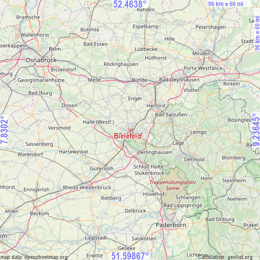
Bielefeld GPS coordinates[2]
52° 1' 59.988" North, 8° 31' 59.988" East
| Map corner | latitude | longitude |
|---|---|---|
| Upper-left | 52.4638°, | 7.8302° |
| Center: | 52.03333°, | 8.53333° |
| Lower-right: | 51.59867°, | 9.23645° |
| Map W x H: | 96.2×96.2 km | = 59.8×59.8mi |
| max Lat: | 55.01917° ⇑27.7% North |
| Bielefeld: | 52.03333° |
| min Lat: | ⇓72.3% South 47.40724° |
| min Long | Bielefeld | max Long |
| 5.92978° | 8.53333° | 14.98853° |
| W 29.2%⇐ | ⇒70.8% E |
Elevation
Elevation of Bielefeld is 111 m = 364 ft, and this is 138.1 m = 453 ft below average elevation for this country.
| Max E: |
1256 m = 4121 ft | 66.5% |
| Avg. | 249.1 m = 817 ft | |
| Bielefeld | 111 m = 364 ft | |
Min E: |
-5 m = -16 ft | 33.5% |
See also: Bielefeld elevation on elevation.city.
Geographical zone
Bielefeld is located in North temperate zone (between Tropic of Cancer and the Arctic Circle). Distance of this North polar circle is 1615.6 km =1003.9 mi to North.| Distance of | km | miles | from Bielefeld |
|---|---|---|---|
| North Pole | 4221.5 | 2623.1 | to North |
| Arctic Circle | 1615.6 | 1003.9 | to North |
| Tropic Cancer | 3179.6 | 1975.7 | to South |
| Equator | 5785.6 | 3595 | to South |


Nearby cities:
15 places around Bielefeld: (largest is in red/bold)
• Bad Salzuflen
15.6 km =9.7 mi,  67°
67°
• Borgholzhausen
17.6 km =10.9 mi,  296°
296°
• Enger
12 km =7.5 mi,  7°
7°
• Gütersloh
17.6 km =10.9 mi,  217°
217°
• Halle
12.2 km =7.6 mi,  284°
284°
• Herford
13.2 km =8.2 mi,  46°
46°
• Hiddenhausen
15.9 km =9.9 mi,  21°
21°
• Lage
18.3 km =11.4 mi,  104°
104°
• Leopoldshöhe
11.5 km =7.1 mi, 101°
• Neuenkirchen
15.3 km =9.5 mi,  319°
319°
• Oerlinghausen
12.4 km =7.7 mi,  134°
134°
• Spenge
12.3 km =7.6 mi,  344°
344°
• Steinhagen
9.8 km =6.1 mi,  247°
247°
• Verl
16.7 km =10.4 mi,  183°
183°
• Werther
9.3 km =5.8 mi, 302°
Sources, notices
• [Note1] Compared only with cities in Germany existing in our database
• [Src1] Map data: © OpenStreetMap contributors (CC-BY-SA)
• [Src2] Other city data from geonames.org with taken over terms of usage.
• [Src3] Geographical zone / Annual Mean Temperature by Robert A. Rohde @ Wikipedia
