Lemgo geodata
Lemgo (North Rhine-Westphalia) is a populated place; located in Germany in Europe/Berlin (GMT+2) time zone. With population of 41,943 people, there are 300 cities with bigger population in this country. Compared to other cities in Germany, 72.3% of cities are located further ↓South; 66.7% of cities are located further →East and 68.5% of cities have higher elevation than Lemgo. Note1
Administrative division(s):
- Level 1: North Rhine-Westphalia
- Level 2: Regierungsbezirk Detmold
- Level 3: Kreis Lippe
- Level 4: Lemgo


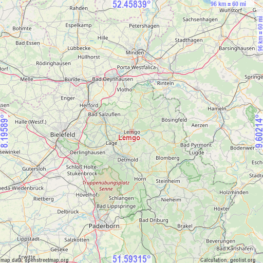
Lemgo GPS coordinates[2]
52° 1' 40.296" North, 8° 53' 56.436" East
| Map corner | latitude | longitude |
|---|---|---|
| Upper-left | 52.45839°, | 8.19589° |
| Center: | 52.02786°, | 8.89901° |
| Lower-right: | 51.59315°, | 9.60214° |
| Map W x H: | 96.2×96.2 km | = 59.8×59.8mi |
| max Lat: | 55.01917° ⇑27.7% North |
| Lemgo: | 52.02786° |
| min Lat: | ⇓72.3% South 47.40724° |
| min Long | Lemgo | max Long |
| 5.92978° | 8.89901° | 14.98853° |
| W 33.3%⇐ | ⇒66.7% E |
Elevation
Elevation of Lemgo is 100 m = 328 ft, and this is 149.1 m = 489 ft below average elevation for this country.
| Max E: |
1256 m = 4121 ft | 68.5% |
| Avg. | 249.1 m = 817 ft | |
| Lemgo | 100 m = 328 ft | |
Min E: |
-5 m = -16 ft | 31.5% |
See also: Lemgo elevation on elevation.city.
Geographical zone
Lemgo is located in North temperate zone (between Tropic of Cancer and the Arctic Circle). Distance of this North polar circle is 1616.2 km =1004.3 mi to North.| Distance of | km | miles | from Lemgo |
|---|---|---|---|
| North Pole | 4222.1 | 2623.5 | to North |
| Arctic Circle | 1616.2 | 1004.3 | to North |
| Tropic Cancer | 3179 | 1975.3 | to South |
| Equator | 5785 | 3594.6 | to South |


Nearby cities:
15 places around Lemgo: (largest is in red/bold)
• Augustdorf
17.5 km =10.9 mi,  221°
221°
• Bad Meinberg
15.8 km =9.8 mi,  158°
158°
• Bad Oeynhausen
21 km =13 mi,  341°
341°
• Bad Salzuflen
12.4 km =7.7 mi,  301°
301°
• Barntrup
15.5 km =9.6 mi,  105°
105°
• Blomberg
16.1 km =10 mi,  125°
125°
• Detmold
10.1 km =6.3 mi,  190°
190°
• Dörentrup
7.2 km =4.5 mi,  78°
78°
• Herford
18.2 km =11.3 mi, 302°
• Horn
17.7 km =11 mi,  169°
169°
• Horn-Bad Meinberg
16.4 km =10.2 mi, 164°
• Lage
8.3 km =5.2 mi,  241°
241°
• Leopoldshöhe
13.8 km =8.6 mi,  262°
262°
• Oerlinghausen
18.1 km =11.2 mi, 243°
• Vlotho
15.5 km =9.6 mi,  350°
350°
Sources, notices
• [Note1] Compared only with cities in Germany existing in our database
• [Src1] Map data: © OpenStreetMap contributors (CC-BY-SA)
• [Src2] Other city data from geonames.org with taken over terms of usage.
• [Src3] Geographical zone / Annual Mean Temperature by Robert A. Rohde @ Wikipedia
