Oerlinghausen geodata
Oerlinghausen (North Rhine-Westphalia) is a populated place; located in Germany in Europe/Berlin (GMT+2) time zone. With population of 17,403 people, there are 915 cities with bigger population in this country. Compared to other cities in Germany, 71.7% of cities are located further ↓South; 69.5% of cities are located further →East and 50.5% of cities have lower elevation than Oerlinghausen. Note1
Administrative division(s):
- Level 1: North Rhine-Westphalia
- Level 2: Regierungsbezirk Detmold
- Level 3: Kreis Lippe
- Level 4: Oerlinghausen


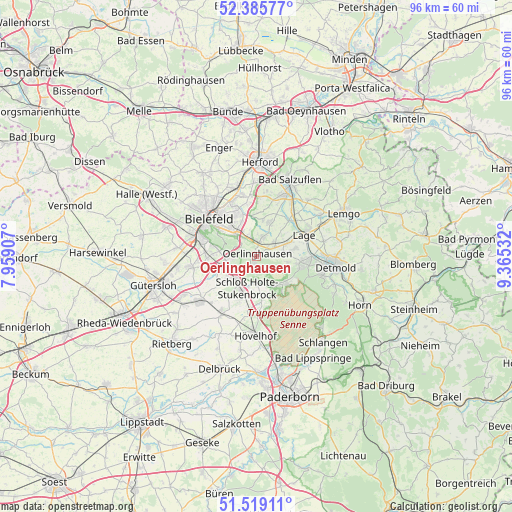
Oerlinghausen GPS coordinates[2]
51° 57' 16.308" North, 8° 39' 43.92" East
| Map corner | latitude | longitude |
|---|---|---|
| Upper-left | 52.38577°, | 7.95907° |
| Center: | 51.95453°, | 8.6622° |
| Lower-right: | 51.51911°, | 9.36532° |
| Map W x H: | 96.4×96.4 km | = 59.9×59.9mi |
| max Lat: | 55.01917° ⇑28.3% North |
| Oerlinghausen: | 51.95453° |
| min Lat: | ⇓71.7% South 47.40724° |
| min Long | Oerlinghausen | max Long |
| 5.92978° | 8.6622° | 14.98853° |
| W 30.5%⇐ | ⇒69.5% E |
Elevation
Elevation of Oerlinghausen is 229 m = 751 ft, and this is 20.1 m = 66 ft below average elevation for this country.
| Max E: |
1256 m = 4121 ft | 49.5% |
| Avg. | 249.1 m = 817 ft | |
| Oerlinghausen | 229 m = 751 ft | |
Min E: |
-5 m = -16 ft | 50.5% |
See also: Germany elevation on elevation.city.
Geographical zone
Oerlinghausen is located in North temperate zone (between Tropic of Cancer and the Arctic Circle). Distance of this North polar circle is 1624.4 km =1009.4 mi to North.| Distance of | km | miles | from Oerlinghausen |
|---|---|---|---|
| North Pole | 4230.3 | 2628.6 | to North |
| Arctic Circle | 1624.4 | 1009.4 | to North |
| Tropic Cancer | 3170.9 | 1970.3 | to South |
| Equator | 5776.8 | 3589.5 | to South |


Nearby cities:
15 places around Oerlinghausen: (largest is in red/bold)
• Augustdorf
6.9 km =4.3 mi,  136°
136°
• Bad Salzuflen
15.7 km =9.8 mi,  21°
21°
• Bielefeld
12.4 km =7.7 mi,  314°
314°
• Detmold
14.6 km =9.1 mi,  97°
97°
• Gütersloh
20.2 km =12.6 mi,  254°
254°
• Herford
17.8 km =11.1 mi,  2°
2°
• Horn
21.5 km =13.4 mi,  115°
115°
• Hövelhof
15.4 km =9.6 mi,  183°
183°
• Lage
9.9 km =6.2 mi,  64°
64°
• Lemgo
18.1 km =11.2 mi, 63°
• Leopoldshöhe
6.9 km =4.3 mi, 21°
• Schlangen
20.5 km =12.7 mi, 141°
• Steinhagen
18.7 km =11.6 mi,  285°
285°
• Verl
12.7 km =7.9 mi,  231°
231°
• Werther
21.6 km =13.4 mi, 309°
Sources, notices
• [Note1] Compared only with cities in Germany existing in our database
• [Src1] Map data: © OpenStreetMap contributors (CC-BY-SA)
• [Src2] Other city data from geonames.org with taken over terms of usage.
• [Src3] Geographical zone / Annual Mean Temperature by Robert A. Rohde @ Wikipedia
