Dörentrup geodata
Dörentrup (North Rhine-Westphalia) is a seat of a fourth-order administrative division; located in Germany in Europe/Berlin (GMT+2) time zone. With population of 8,713 people, there are 1842 cities with bigger population in this country. Compared to other cities in Germany, 72.4% of cities are located further ↓South; 65.4% of cities are located further →East and 59.6% of cities have higher elevation than Dörentrup. Note1
Administrative division(s):
- Level 1: North Rhine-Westphalia
- Level 2: Regierungsbezirk Detmold
- Level 3: Kreis Lippe
- Level 4: Dörentrup


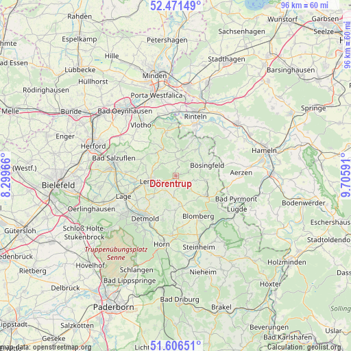
Dörentrup GPS coordinates[2]
52° 2' 27.924" North, 9° 0' 10.008" East
| Map corner | latitude | longitude |
|---|---|---|
| Upper-left | 52.47149°, | 8.29966° |
| Center: | 52.04109°, | 9.00278° |
| Lower-right: | 51.60651°, | 9.70591° |
| Map W x H: | 96.2×96.2 km | = 59.8×59.8mi |
| max Lat: | 55.01917° ⇑27.6% North |
| Dörentrup: | 52.04109° |
| min Lat: | ⇓72.4% South 47.40724° |
| min Long | Dörentrup | max Long |
| 5.92978° | 9.00278° | 14.98853° |
| W 34.6%⇐ | ⇒65.4% E |
Elevation
Elevation of Dörentrup is 156 m = 512 ft, and this is 93.1 m = 305 ft below average elevation for this country.
| Max E: |
1256 m = 4121 ft | 59.6% |
| Avg. | 249.1 m = 817 ft | |
| Dörentrup | 156 m = 512 ft | |
Min E: |
-5 m = -16 ft | 40.4% |
See also: Germany elevation on elevation.city.
Geographical zone
Dörentrup is located in North temperate zone (between Tropic of Cancer and the Arctic Circle). Distance of this North polar circle is 1614.7 km =1003.3 mi to North.| Distance of | km | miles | from Dörentrup |
|---|---|---|---|
| North Pole | 4220.6 | 2622.6 | to North |
| Arctic Circle | 1614.7 | 1003.3 | to North |
| Tropic Cancer | 3180.5 | 1976.3 | to South |
| Equator | 5786.4 | 3595.5 | to South |


Nearby cities:
15 places around Dörentrup: (largest is in red/bold)
• Aerzen
17.5 km =10.9 mi,  86°
86°
• Bad Meinberg
16.2 km =10.1 mi,  184°
184°
• Bad Pyrmont
18.2 km =11.3 mi,  109°
109°
• Bad Salzuflen
18.4 km =11.4 mi,  285°
285°
• Barntrup
9.6 km =6 mi,  125°
125°
• Blomberg
12.4 km =7.7 mi,  151°
151°
• Detmold
14.4 km =8.9 mi,  217°
217°
• Horn
19.3 km =12 mi,  191°
191°
• Horn-Bad Meinberg
17.5 km =10.9 mi, 189°
• Lage
15.3 km =9.5 mi,  249°
249°
• Lemgo
7.2 km =4.5 mi,  258°
258°
• Lügde
19.1 km =11.9 mi,  118°
118°
• Rinteln
16.9 km =10.5 mi,  17°
17°
• Steinheim
19.9 km =12.4 mi,  162°
162°
• Vlotho
16.9 km =10.5 mi,  324°
324°
Sources, notices
• [Note1] Compared only with cities in Germany existing in our database
• [Src1] Map data: © OpenStreetMap contributors (CC-BY-SA)
• [Src2] Other city data from geonames.org with taken over terms of usage.
• [Src3] Geographical zone / Annual Mean Temperature by Robert A. Rohde @ Wikipedia
