Bad Frankenhausen geodata
Bad Frankenhausen (Thuringia) is a populated place; located in Germany in Europe/Berlin (GMT+2) time zone. With population of 8,824 people, there are 1817 cities with bigger population in this country. Compared to other cities in Germany, 64.1% of cities are located further ↓South; 68.4% of cities are located further ←West and 62.2% of cities have higher elevation than Bad Frankenhausen. Note1
Administrative division(s):
- Level 1: Thuringia
- Level 3: Kyffhäuserkreis
- Level 4: Bad Frankenhausen/Kyffhäuser


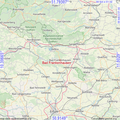
Bad Frankenhausen GPS coordinates[2]
51° 21' 21.924" North, 11° 5' 59.172" East
| Map corner | latitude | longitude |
|---|---|---|
| Upper-left | 51.79307°, | 10.39665° |
| Center: | 51.35609°, | 11.09977° |
| Lower-right: | 50.9149°, | 11.8029° |
| Map W x H: | 97.6×97.6 km | = 60.6×60.6mi |
| max Lat: | 55.01917° ⇑35.9% North |
| Bad Frankenhausen: | 51.35609° |
| min Lat: | ⇓64.1% South 47.40724° |
| min Long | Bad Frankenhaus | max Long |
| 5.92978° | 11.09977° | 14.98853° |
| W 68.4%⇐ | ⇒31.6% E |
Elevation
Elevation of Bad Frankenhausen is 137 m = 449 ft, and this is 112.1 m = 368 ft below average elevation for this country.
| Max E: |
1256 m = 4121 ft | 62.2% |
| Avg. | 249.1 m = 817 ft | |
| Bad Frankenhausen | 137 m = 449 ft | |
Min E: |
-5 m = -16 ft | 37.8% |
See also: Germany elevation on elevation.city.
Geographical zone
Bad Frankenhausen is located in North temperate zone (between Tropic of Cancer and the Arctic Circle). Distance of this North polar circle is 1690.9 km =1050.7 mi to North.| Distance of | km | miles | from Bad Frankenhausen |
|---|---|---|---|
| North Pole | 4296.8 | 2669.9 | to North |
| Arctic Circle | 1690.9 | 1050.7 | to North |
| Tropic Cancer | 3104.3 | 1928.9 | to South |
| Equator | 5710.3 | 3548.2 | to South |


Nearby cities:
15 places around Bad Frankenhausen: (largest is in red/bold)
• Bendeleben
6.7 km =4.2 mi,  285°
285°
• Bilzingsleben
8.4 km =5.2 mi,  195°
195°
• Bretleben
9.6 km =6 mi,  105°
105°
• Esperstedt
5.6 km =3.5 mi,  100°
100°
• Göllingen
6.1 km =3.8 mi,  256°
256°
• Hachelbich
9.4 km =5.8 mi, 261°
• Heldrungen
10.2 km =6.3 mi,  126°
126°
• Ichstedt
7.6 km =4.7 mi,  66°
66°
• Kelbra
9.7 km =6 mi,  335°
335°
• Oberbösa
9.4 km =5.8 mi,  217°
217°
• Oldisleben
7.1 km =4.4 mi,  136°
136°
• Ringleben
8.2 km =5.1 mi,  81°
81°
• Rottleben
3.7 km =2.3 mi,  280°
280°
• Steinthaleben
6.8 km =4.2 mi,  309°
309°
• Tilleda
7.7 km =4.8 mi,  21°
21°
In other languages:
- In German: Bad Frankenhausen/Kyffhäuser
- In Italian: Bad Frankenhausen/Kyffhäuser
- In Russian: Бад-Франкенхаузен-Кифхойзер
- In Chinese: 巴特弗兰肯豪森
Sources, notices
• [Note1] Compared only with cities in Germany existing in our database
• [Src1] Map data: © OpenStreetMap contributors (CC-BY-SA)
• [Src2] Other city data from geonames.org with taken over terms of usage.
• [Src3] Geographical zone / Annual Mean Temperature by Robert A. Rohde @ Wikipedia
