Hachelbich geodata
Hachelbich (Thuringia) is a populated place; located in Germany in Europe/Berlin (GMT+2) time zone. With population of 630 people, there are 8657 cities with bigger population in this country. Compared to other cities in Germany, 63.9% of cities are located further ↓South; 66.4% of cities are located further ←West and 55.5% of cities have higher elevation than Hachelbich. Note1


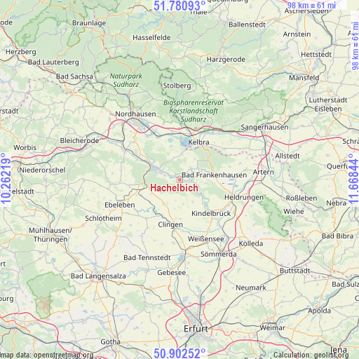
Hachelbich GPS coordinates[2]
51° 20' 37.788" North, 10° 57' 55.116" East
| Map corner | latitude | longitude |
|---|---|---|
| Upper-left | 51.78093°, | 10.26219° |
| Center: | 51.34383°, | 10.96531° |
| Lower-right: | 50.90252°, | 11.66844° |
| Map W x H: | 97.7×97.7 km | = 60.7×60.7mi |
| max Lat: | 55.01917° ⇑36.1% North |
| Hachelbich: | 51.34383° |
| min Lat: | ⇓63.9% South 47.40724° |
| min Long | Hachelbich | max Long |
| 5.92978° | 10.96531° | 14.98853° |
| W 66.4%⇐ | ⇒33.6% E |
Elevation
Elevation of Hachelbich is 185 m = 607 ft, and this is 64.1 m = 210 ft below average elevation for this country.
| Max E: |
1256 m = 4121 ft | 55.5% |
| Avg. | 249.1 m = 817 ft | |
| Hachelbich | 185 m = 607 ft | |
Min E: |
-5 m = -16 ft | 44.5% |
See also: Germany elevation on elevation.city.
Geographical zone
Hachelbich is located in North temperate zone (between Tropic of Cancer and the Arctic Circle). Distance of this North polar circle is 1692.3 km =1051.5 mi to North.| Distance of | km | miles | from Hachelbich |
|---|---|---|---|
| North Pole | 4298.2 | 2670.8 | to North |
| Arctic Circle | 1692.3 | 1051.5 | to North |
| Tropic Cancer | 3103 | 1928.1 | to South |
| Equator | 5708.9 | 3547.3 | to South |


Nearby cities:
15 places around Hachelbich: (largest is in red/bold)
• Auleben
9.5 km =5.9 mi,  344°
344°
• Bad Frankenhausen
9.4 km =5.8 mi,  81°
81°
• Badra
7 km =4.3 mi,  5°
5°
• Bendeleben
4.3 km =2.7 mi,  42°
42°
• Bilzingsleben
9.7 km =6 mi,  133°
133°
• Frömmstedt
10.6 km =6.6 mi,  150°
150°
• Göllingen
3.4 km =2.1 mi,  90°
90°
• Kelbra
11.5 km =7.1 mi,  27°
27°
• Niederbösa
8.9 km =5.5 mi,  164°
164°
• Oberbösa
7 km =4.3 mi, 149°
• Rottleben
6.1 km =3.8 mi,  70°
70°
• Sondershausen
7.2 km =4.5 mi,  293°
293°
• Steinthaleben
7 km =4.3 mi, 36°
• Topfstedt
8.6 km =5.3 mi,  179°
179°
• Trebra
6.8 km =4.2 mi,  169°
169°
Sources, notices
• [Note1] Compared only with cities in Germany existing in our database
• [Src1] Map data: © OpenStreetMap contributors (CC-BY-SA)
• [Src2] Other city data from geonames.org with taken over terms of usage.
• [Src3] Geographical zone / Annual Mean Temperature by Robert A. Rohde @ Wikipedia
