Kelbra geodata
Kelbra (Saxony-Anhalt) is a populated place; located in Germany in Europe/Berlin (GMT+2) time zone. With population of 3,117 people, there are 3902 cities with bigger population in this country. Compared to other cities in Germany, 65.4% of cities are located further ↓South; 67.6% of cities are located further ←West and 58.6% of cities have higher elevation than Kelbra. Note1
Administrative division(s):
- Level 1: Saxony-Anhalt
- Level 3: Mansfeld-Südharz
- Level 4: Kelbra (Kyffhäuser)


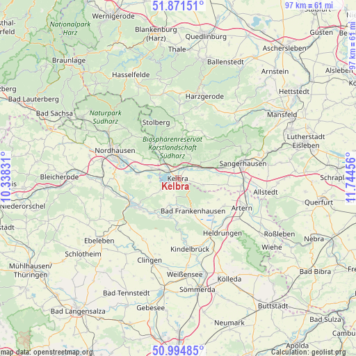
Kelbra GPS coordinates[2]
51° 26' 7.008" North, 11° 2' 29.148" East
| Map corner | latitude | longitude |
|---|---|---|
| Upper-left | 51.87151°, | 10.33831° |
| Center: | 51.43528°, | 11.04143° |
| Lower-right: | 50.99485°, | 11.74456° |
| Map W x H: | 97.5×97.5 km | = 60.6×60.6mi |
| max Lat: | 55.01917° ⇑34.6% North |
| Kelbra: | 51.43528° |
| min Lat: | ⇓65.4% South 47.40724° |
| min Long | Kelbra | max Long |
| 5.92978° | 11.04143° | 14.98853° |
| W 67.6%⇐ | ⇒32.4% E |
Elevation
Elevation of Kelbra is 163 m = 535 ft, and this is 86.1 m = 282 ft below average elevation for this country.
| Max E: |
1256 m = 4121 ft | 58.6% |
| Avg. | 249.1 m = 817 ft | |
| Kelbra | 163 m = 535 ft | |
Min E: |
-5 m = -16 ft | 41.4% |
See also: Germany elevation on elevation.city.
Geographical zone
Kelbra is located in North temperate zone (between Tropic of Cancer and the Arctic Circle). Distance of this North polar circle is 1682.1 km =1045.2 mi to North.| Distance of | km | miles | from Kelbra |
|---|---|---|---|
| North Pole | 4288 | 2664.4 | to North |
| Arctic Circle | 1682.1 | 1045.2 | to North |
| Tropic Cancer | 3113.1 | 1934.4 | to South |
| Equator | 5719.1 | 3553.7 | to South |


Nearby cities:
15 places around Kelbra: (largest is in red/bold)
• Auleben
7.8 km =4.8 mi,  262°
262°
• Bad Frankenhausen
9.7 km =6 mi,  155°
155°
• Badra
5.6 km =3.5 mi,  235°
235°
• Bendeleben
7.4 km =4.6 mi,  199°
199°
• Bennungen
6 km =3.7 mi,  61°
61°
• Berga
3.3 km =2.1 mi,  313°
313°
• Breitungen
7 km =4.3 mi,  5°
5°
• Brücken
10.9 km =6.8 mi,  84°
84°
• Göllingen
10.4 km =6.5 mi,  190°
190°
• Görsbach
7.8 km =4.8 mi,  292°
292°
• Rottleben
8.1 km =5 mi,  177°
177°
• Roßla
3.9 km =2.4 mi,  37°
37°
• Steinthaleben
4.6 km =2.9 mi, 194°
• Tilleda
7.1 km =4.4 mi,  103°
103°
• Uftrungen
8.2 km =5.1 mi,  329°
329°
Sources, notices
• [Note1] Compared only with cities in Germany existing in our database
• [Src1] Map data: © OpenStreetMap contributors (CC-BY-SA)
• [Src2] Other city data from geonames.org with taken over terms of usage.
• [Src3] Geographical zone / Annual Mean Temperature by Robert A. Rohde @ Wikipedia
