Steinthaleben geodata
Steinthaleben (Thuringia) is a populated place; located in Germany in Europe/Berlin (GMT+2) time zone. With population of 548 people, there are 9089 cities with bigger population in this country. Compared to other cities in Germany, 64.7% of cities are located further ↓South; 67.4% of cities are located further ←West and 56.7% of cities have higher elevation than Steinthaleben. Note1


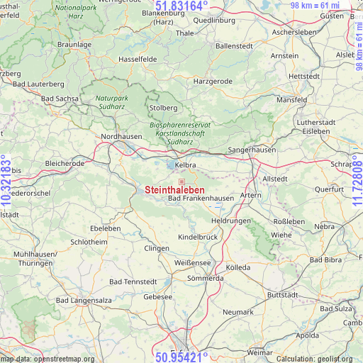
Steinthaleben GPS coordinates[2]
51° 23' 42.108" North, 11° 1' 29.82" East
| Map corner | latitude | longitude |
|---|---|---|
| Upper-left | 51.83164°, | 10.32183° |
| Center: | 51.39503°, | 11.02495° |
| Lower-right: | 50.95421°, | 11.72808° |
| Map W x H: | 97.6×97.6 km | = 60.6×60.6mi |
| max Lat: | 55.01917° ⇑35.3% North |
| Steinthaleben: | 51.39503° |
| min Lat: | ⇓64.7% South 47.40724° |
| min Long | Steinthaleben | max Long |
| 5.92978° | 11.02495° | 14.98853° |
| W 67.4%⇐ | ⇒32.6% E |
Elevation
Elevation of Steinthaleben is 177 m = 581 ft, and this is 72.1 m = 237 ft below average elevation for this country.
| Max E: |
1256 m = 4121 ft | 56.7% |
| Avg. | 249.1 m = 817 ft | |
| Steinthaleben | 177 m = 581 ft | |
Min E: |
-5 m = -16 ft | 43.3% |
See also: Germany elevation on elevation.city.
Geographical zone
Steinthaleben is located in North temperate zone (between Tropic of Cancer and the Arctic Circle). Distance of this North polar circle is 1686.6 km =1048 mi to North.| Distance of | km | miles | from Steinthaleben |
|---|---|---|---|
| North Pole | 4292.5 | 2667.2 | to North |
| Arctic Circle | 1686.6 | 1048 | to North |
| Tropic Cancer | 3108.7 | 1931.7 | to South |
| Equator | 5714.6 | 3550.9 | to South |


Nearby cities:
15 places around Steinthaleben: (largest is in red/bold)
• Auleben
7.5 km =4.7 mi,  297°
297°
• Bad Frankenhausen
6.8 km =4.2 mi,  129°
129°
• Badra
3.8 km =2.4 mi,  290°
290°
• Bendeleben
2.8 km =1.7 mi,  206°
206°
• Bennungen
9.8 km =6.1 mi,  41°
41°
• Berga
6.8 km =4.2 mi,  349°
349°
• Breitungen
11.6 km =7.2 mi,  9°
9°
• Göllingen
5.8 km =3.6 mi,  187°
187°
• Görsbach
9.6 km =6 mi,  320°
320°
• Hachelbich
7 km =4.3 mi,  216°
216°
• Kelbra
4.6 km =2.9 mi, 14°
• Rottleben
4 km =2.5 mi,  156°
156°
• Roßla
8.4 km =5.2 mi,  24°
24°
• Sondershausen
11.1 km =6.9 mi,  255°
255°
• Tilleda
8.5 km =5.3 mi,  70°
70°
Sources, notices
• [Note1] Compared only with cities in Germany existing in our database
• [Src1] Map data: © OpenStreetMap contributors (CC-BY-SA)
• [Src2] Other city data from geonames.org with taken over terms of usage.
• [Src3] Geographical zone / Annual Mean Temperature by Robert A. Rohde @ Wikipedia
