Oberroth geodata
Oberroth (Bavaria) is a seat of a fourth-order administrative division; located in Germany in Europe/Berlin (GMT+2) time zone. With population of 824 people, there are 7807 cities with bigger population in this country. Compared to other cities in Germany, 93% of cities are located further ↑North; 53.2% of cities are located further ←West and 91.5% of cities have lower elevation than Oberroth. Note1
Administrative division(s):
- Level 1: Bavaria
- Level 2: Swabia
- Level 3: Landkreis Neu-Ulm
- Level 4: Oberroth


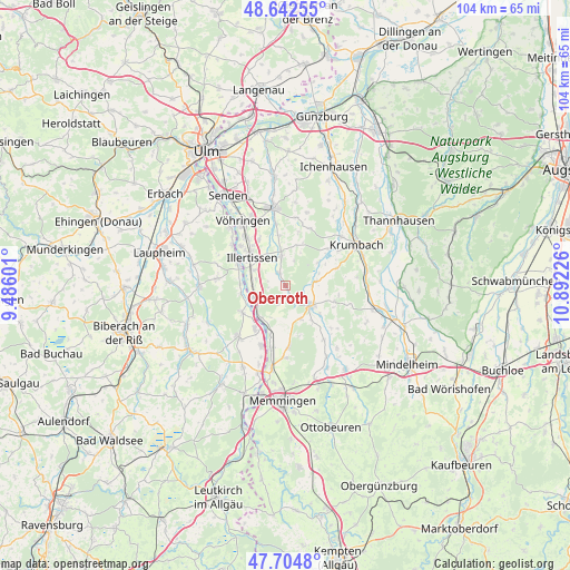
Oberroth GPS coordinates[2]
48° 10' 32.952" North, 10° 11' 20.868" East
| Map corner | latitude | longitude |
|---|---|---|
| Upper-left | 48.64255°, | 9.48601° |
| Center: | 48.17582°, | 10.18913° |
| Lower-right: | 47.7048°, | 10.89226° |
| Map W x H: | 104.3×104.3 km | = 64.8×64.8mi |
| max Lat: | 55.01917° ⇑93% North |
| Oberroth: | 48.17582° |
| min Lat: | ⇓7% South 47.40724° |
| min Long | Oberroth | max Long |
| 5.92978° | 10.18913° | 14.98853° |
| W 53.2%⇐ | ⇒46.8% E |
Elevation
Elevation of Oberroth is 535 m = 1755 ft, and this is 285.9 m = 938 ft above average elevation for this country.
| Max E: |
1256 m = 4121 ft | 8.5% |
| Oberroth | 535 m 1755 ft | |
| Avg. | 249.1 m = 817 ft | |
Min E: |
-5 m = -16 ft | 91.5% |
See also: Germany elevation on elevation.city.
Geographical zone
Oberroth is located in North temperate zone (between Tropic of Cancer and the Arctic Circle). Distance of this North polar circle is 2044.5 km =1270.4 mi to North.| Distance of | km | miles | from Oberroth |
|---|---|---|---|
| North Pole | 4650.4 | 2889.6 | to North |
| Arctic Circle | 2044.5 | 1270.4 | to North |
| Tropic Cancer | 2750.7 | 1709.2 | to South |
| Equator | 5356.6 | 3328.4 | to South |


Nearby cities:
15 places around Oberroth: (largest is in red/bold)
• Altenstadt
5.8 km =3.6 mi,  252°
252°
• Babenhausen
5.9 km =3.7 mi,  125°
125°
• Buch
5.5 km =3.4 mi,  353°
353°
• Dettingen an der Iller
10 km =6.2 mi,  212°
212°
• Dietenheim
9.5 km =5.9 mi,  294°
294°
• Ebershausen
9.9 km =6.2 mi,  70°
70°
• Illertissen
8.3 km =5.2 mi,  309°
309°
• Kellmünz
7.5 km =4.7 mi,  216°
216°
• Kettershausen
5.8 km =3.6 mi,  81°
81°
• Kirchberg an der Iller
9.2 km =5.7 mi,  238°
238°
• Kirchhaslach
9.4 km =5.8 mi,  107°
107°
• Osterberg
3.3 km =2.1 mi, 210°
• Pless
9.6 km =6 mi,  196°
196°
• Unterroth
2.6 km =1.6 mi,  328°
328°
• Winterrieden
6.7 km =4.2 mi,  155°
155°
Sources, notices
• [Note1] Compared only with cities in Germany existing in our database
• [Src1] Map data: © OpenStreetMap contributors (CC-BY-SA)
• [Src2] Other city data from geonames.org with taken over terms of usage.
• [Src3] Geographical zone / Annual Mean Temperature by Robert A. Rohde @ Wikipedia
