Altenstadt geodata
Altenstadt (Bavaria) is a populated place; located in Germany in Europe/Berlin (GMT+2) time zone. With population of 4,790 people, there are 2906 cities with bigger population in this country. Compared to other cities in Germany, 93.2% of cities are located further ↑North; 51.8% of cities are located further ←West and 91.1% of cities have lower elevation than Altenstadt. Note1
Administrative division(s):
- Level 1: Bavaria
- Level 2: Swabia
- Level 3: Landkreis Neu-Ulm
- Level 4: Altenstadt, Markt


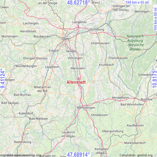
Altenstadt GPS coordinates[2]
48° 9' 37.08" North, 10° 6' 51.732" East
| Map corner | latitude | longitude |
|---|---|---|
| Upper-left | 48.62718°, | 9.41124° |
| Center: | 48.1603°, | 10.11437° |
| Lower-right: | 47.68914°, | 10.8175° |
| Map W x H: | 104.3×104.3 km | = 64.8×64.8mi |
| max Lat: | 55.01917° ⇑93.2% North |
| Altenstadt: | 48.1603° |
| min Lat: | ⇓6.8% South 47.40724° |
| min Long | Altenstadt | max Long |
| 5.92978° | 10.11437° | 14.98853° |
| W 51.8%⇐ | ⇒48.2% E |
Elevation
Elevation of Altenstadt is 528 m = 1732 ft, and this is 278.9 m = 915 ft above average elevation for this country.
| Max E: |
1256 m = 4121 ft | 8.9% |
| Altenstadt | 528 m 1732 ft | |
| Avg. | 249.1 m = 817 ft | |
Min E: |
-5 m = -16 ft | 91.1% |
See also: Germany elevation on elevation.city.
Geographical zone
Altenstadt is located in North temperate zone (between Tropic of Cancer and the Arctic Circle). Distance of this North polar circle is 2046.3 km =1271.5 mi to North.| Distance of | km | miles | from Altenstadt |
|---|---|---|---|
| North Pole | 4652.1 | 2890.7 | to North |
| Arctic Circle | 2046.3 | 1271.5 | to North |
| Tropic Cancer | 2749 | 1708.1 | to South |
| Equator | 5354.9 | 3327.4 | to South |


Nearby cities:
15 places around Altenstadt: (largest is in red/bold)
• Buch
8.7 km =5.4 mi,  34°
34°
• Dettingen an der Iller
6.7 km =4.2 mi,  178°
178°
• Dietenheim
6.4 km =4 mi,  330°
330°
• Erolzheim
8.4 km =5.2 mi,  201°
201°
• Fellheim
10.1 km =6.3 mi,  163°
163°
• Illertissen
7.1 km =4.4 mi,  353°
353°
• Kellmünz
4.4 km =2.7 mi,  166°
166°
• Kirchberg an der Iller
3.8 km =2.4 mi,  217°
217°
• Kirchdorf
9.3 km =5.8 mi, 174°
• Oberroth
5.8 km =3.6 mi,  72°
72°
• Osterberg
4 km =2.5 mi,  106°
106°
• Pless
8 km =5 mi, 159°
• Unterroth
5.8 km =3.6 mi,  46°
46°
• Wain
7.6 km =4.7 mi,  294°
294°
• Winterrieden
9.3 km =5.8 mi,  117°
117°
Sources, notices
• [Note1] Compared only with cities in Germany existing in our database
• [Src1] Map data: © OpenStreetMap contributors (CC-BY-SA)
• [Src2] Other city data from geonames.org with taken over terms of usage.
• [Src3] Geographical zone / Annual Mean Temperature by Robert A. Rohde @ Wikipedia
