Klöden geodata
Klöden (Saxony-Anhalt) is a populated place; located in Germany in Europe/Berlin (GMT+2) time zone. With population of 648 people, there are 8563 cities with bigger population in this country. Compared to other cities in Germany, 69.5% of cities are located further ↓South; 91% of cities are located further ←West and 72.3% of cities have higher elevation than Klöden. Note1
Administrative division(s):
- Level 1: Saxony-Anhalt
- Level 3: Landkreis Wittenberg
- Level 4: Jessen (Elster)


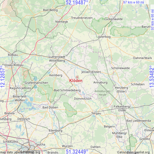
Klöden GPS coordinates[2]
51° 45' 42.408" North, 12° 49' 54.084" East
| Map corner | latitude | longitude |
|---|---|---|
| Upper-left | 52.19487°, | 12.12857° |
| Center: | 51.76178°, | 12.83169° |
| Lower-right: | 51.32449°, | 13.53482° |
| Map W x H: | 96.8×96.8 km | = 60.1×60.1mi |
| max Lat: | 55.01917° ⇑30.5% North |
| Klöden: | 51.76178° |
| min Lat: | ⇓69.5% South 47.40724° |
| min Long | Klöden | max Long |
| 5.92978° | 12.83169° | 14.98853° |
| W 91%⇐ | ⇒9% E |
Elevation
Elevation of Klöden is 76 m = 249 ft, and this is 173.1 m = 568 ft below average elevation for this country.
| Max E: |
1256 m = 4121 ft | 72.3% |
| Avg. | 249.1 m = 817 ft | |
| Klöden | 76 m = 249 ft | |
Min E: |
-5 m = -16 ft | 27.7% |
See also: Germany elevation on elevation.city.
Geographical zone
Klöden is located in North temperate zone (between Tropic of Cancer and the Arctic Circle). Distance of this North polar circle is 1645.8 km =1022.7 mi to North.| Distance of | km | miles | from Klöden |
|---|---|---|---|
| North Pole | 4251.7 | 2641.9 | to North |
| Arctic Circle | 1645.8 | 1022.7 | to North |
| Tropic Cancer | 3149.5 | 1957 | to South |
| Equator | 5755.4 | 3576.2 | to South |


Nearby cities:
15 places around Klöden: (largest is in red/bold)
• Ateritz
14 km =8.7 mi,  259°
259°
• Axien
7.7 km =4.8 mi,  150°
150°
• Bad Schmiedeberg
10.8 km =6.7 mi,  218°
218°
• Dabrun
11.6 km =7.2 mi,  313°
313°
• Dommitzsch
13.9 km =8.6 mi,  166°
166°
• Elster
7.6 km =4.7 mi,  356°
356°
• Jessen
9.3 km =5.8 mi,  67°
67°
• Kemberg
13.8 km =8.6 mi,  274°
274°
• Meuro
10.4 km =6.5 mi,  246°
246°
• Mühlanger
11.3 km =7 mi,  330°
330°
• Prettin
12.9 km =8 mi, 150°
• Pretzsch
5.5 km =3.4 mi,  198°
198°
• Rackith
11 km =6.8 mi,  294°
294°
• Wartenburg
6.4 km =4 mi, 325°
• Zörnigall
13.1 km =8.1 mi,  336°
336°
Sources, notices
• [Note1] Compared only with cities in Germany existing in our database
• [Src1] Map data: © OpenStreetMap contributors (CC-BY-SA)
• [Src2] Other city data from geonames.org with taken over terms of usage.
• [Src3] Geographical zone / Annual Mean Temperature by Robert A. Rohde @ Wikipedia
