Kossa geodata
Kossa (Saxony) is a populated place; located in Germany in Europe/Berlin (GMT+2) time zone. With population of 2,514 people, there are 4422 cities with bigger population in this country. Compared to other cities in Germany, 67.9% of cities are located further ↓South; 89.6% of cities are located further ←West and 65% of cities have higher elevation than Kossa. Note1


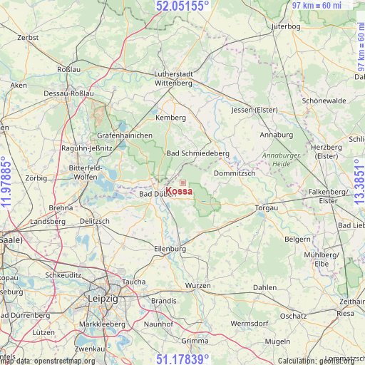
Kossa GPS coordinates[2]
51° 37' 1.452" North, 12° 40' 55.092" East
| Map corner | latitude | longitude |
|---|---|---|
| Upper-left | 52.05155°, | 11.97885° |
| Center: | 51.61707°, | 12.68197° |
| Lower-right: | 51.17839°, | 13.3851° |
| Map W x H: | 97.1×97.1 km | = 60.3×60.3mi |
| max Lat: | 55.01917° ⇑32.1% North |
| Kossa: | 51.61707° |
| min Lat: | ⇓67.9% South 47.40724° |
| min Long | Kossa | max Long |
| 5.92978° | 12.68197° | 14.98853° |
| W 89.6%⇐ | ⇒10.4% E |
Elevation
Elevation of Kossa is 120 m = 394 ft, and this is 129.1 m = 424 ft below average elevation for this country.
| Max E: |
1256 m = 4121 ft | 65% |
| Avg. | 249.1 m = 817 ft | |
| Kossa | 120 m = 394 ft | |
Min E: |
-5 m = -16 ft | 35% |
See also: Germany elevation on elevation.city.
Geographical zone
Kossa is located in North temperate zone (between Tropic of Cancer and the Arctic Circle). Distance of this North polar circle is 1661.9 km =1032.7 mi to North.| Distance of | km | miles | from Kossa |
|---|---|---|---|
| North Pole | 4267.8 | 2651.9 | to North |
| Arctic Circle | 1661.9 | 1032.7 | to North |
| Tropic Cancer | 3133.4 | 1947 | to South |
| Equator | 5739.3 | 3566.2 | to South |


Nearby cities:
15 places around Kossa: (largest is in red/bold)
• Ateritz
14 km =8.7 mi,  345°
345°
• Bad Düben
7.3 km =4.5 mi,  247°
247°
• Bad Schmiedeberg
8.4 km =5.2 mi,  25°
25°
• Doberschütz
13.9 km =8.6 mi,  160°
160°
• Dommitzsch
13.9 km =8.6 mi,  79°
79°
• Krina
14.1 km =8.8 mi,  287°
287°
• Laußig
8.6 km =5.3 mi,  204°
204°
• Meuro
12 km =7.5 mi,  3°
3°
• Pretzsch
13.8 km =8.6 mi,  38°
38°
• Rösa
13.2 km =8.2 mi,  269°
269°
• Schköna
12.3 km =7.6 mi,  305°
305°
• Schwemsal
8.7 km =5.4 mi,  277°
277°
• Söllichau
3.1 km =1.9 mi, 310°
• Trossin
9.3 km =5.8 mi,  90°
90°
• Zschepplin
14.2 km =8.8 mi, 203°
Sources, notices
• [Note1] Compared only with cities in Germany existing in our database
• [Src1] Map data: © OpenStreetMap contributors (CC-BY-SA)
• [Src2] Other city data from geonames.org with taken over terms of usage.
• [Src3] Geographical zone / Annual Mean Temperature by Robert A. Rohde @ Wikipedia
