Bad Schmiedeberg geodata
Bad Schmiedeberg (Saxony-Anhalt) is a populated place; located in Germany in Europe/Berlin (GMT+2) time zone. With population of 4,241 people, there are 3160 cities with bigger population in this country. Compared to other cities in Germany, 68.8% of cities are located further ↓South; 90.2% of cities are located further ←West and 69% of cities have higher elevation than Bad Schmiedeberg. Note1
Administrative division(s):
- Level 1: Saxony-Anhalt
- Level 3: Landkreis Wittenberg
- Level 4: Bad Schmiedeberg


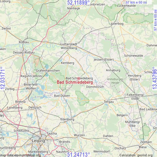
Bad Schmiedeberg GPS coordinates[2]
51° 41' 6.576" North, 12° 44' 5.388" East
| Map corner | latitude | longitude |
|---|---|---|
| Upper-left | 52.11899°, | 12.03171° |
| Center: | 51.68516°, | 12.73483° |
| Lower-right: | 51.24713°, | 13.43796° |
| Map W x H: | 96.9×96.9 km | = 60.2×60.2mi |
| max Lat: | 55.01917° ⇑31.2% North |
| Bad Schmiedeberg: | 51.68516° |
| min Lat: | ⇓68.8% South 47.40724° |
| min Long | Bad Schmiedeber | max Long |
| 5.92978° | 12.73483° | 14.98853° |
| W 90.2%⇐ | ⇒9.8% E |
Elevation
Elevation of Bad Schmiedeberg is 97 m = 318 ft, and this is 152.1 m = 499 ft below average elevation for this country.
| Max E: |
1256 m = 4121 ft | 69% |
| Avg. | 249.1 m = 817 ft | |
| Bad Schmiedeberg | 97 m = 318 ft | |
Min E: |
-5 m = -16 ft | 31% |
See also: Germany elevation on elevation.city.
Geographical zone
Bad Schmiedeberg is located in North temperate zone (between Tropic of Cancer and the Arctic Circle). Distance of this North polar circle is 1654.3 km =1027.9 mi to North.| Distance of | km | miles | from Bad Schmiedeberg |
|---|---|---|---|
| North Pole | 4260.2 | 2647.2 | to North |
| Arctic Circle | 1654.3 | 1027.9 | to North |
| Tropic Cancer | 3140.9 | 1951.7 | to South |
| Equator | 5746.9 | 3571 | to South |


Nearby cities:
15 places around Bad Schmiedeberg: (largest is in red/bold)
• Ateritz
9.3 km =5.8 mi,  310°
310°
• Axien
10.7 km =6.6 mi,  80°
80°
• Dommitzsch
11.1 km =6.9 mi,  116°
116°
• Kemberg
12 km =7.5 mi,  323°
323°
• Klöden
10.8 km =6.7 mi,  38°
38°
• Kossa
8.4 km =5.2 mi,  205°
205°
• Meuro
5.3 km =3.3 mi,  327°
327°
• Prettin
13.3 km =8.3 mi,  101°
101°
• Pretzsch
5.9 km =3.7 mi,  56°
56°
• Rackith
13.6 km =8.5 mi,  345°
345°
• Rotta
12.7 km =7.9 mi, 313°
• Schköna
13.6 km =8.5 mi,  268°
268°
• Schwemsal
13.9 km =8.6 mi,  242°
242°
• Söllichau
8.2 km =5.1 mi,  227°
227°
• Trossin
9.5 km =5.9 mi,  143°
143°
Sources, notices
• [Note1] Compared only with cities in Germany existing in our database
• [Src1] Map data: © OpenStreetMap contributors (CC-BY-SA)
• [Src2] Other city data from geonames.org with taken over terms of usage.
• [Src3] Geographical zone / Annual Mean Temperature by Robert A. Rohde @ Wikipedia
